Back to KPI list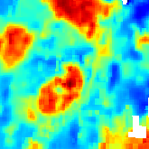 Land Surface Temperature
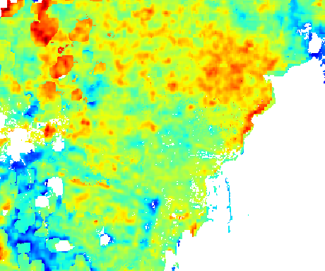 Land Surface Temperature
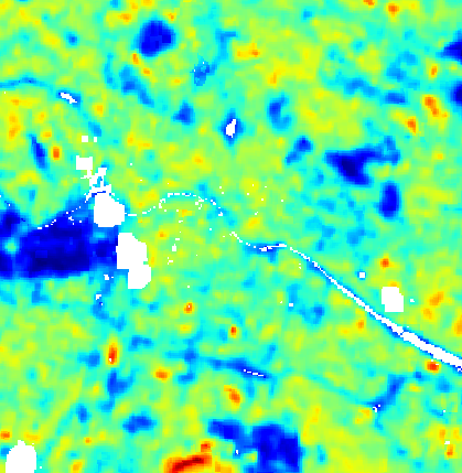 Land Surface Temperature
 Land Surface Temperature
Land Surface Temperature
Risksvv0
Responsible:Niccolò Calandri
Layer Land Surface Temperature on real sites
Real Estate UK
Catania
Berlino Quarter
Mina el Cerrejon
Land Surface Temperature (LST)
Overview
Land Surface Temperature (LST) is the measurement of the temperature of the Earth's surface, distinct from the air temperature measured by meteorological stations. Expressed in degrees Celsius (°C), LST provides a direct indicator of the effects of global warming and climate change on the land surface, with particular relevance for assessing the Urban Heat Island (UHI) effect and thermal stress conditions of ecosystems.
High LST values are associated with soil sealing, reduced vegetation cover, increased evapotranspiration under water stress, and reduced ecosystem cooling services. The KPI is inverted: higher surface temperatures indicate less favourable conditions for biodiversity and ecosystems.
Calculation Methodology
The calculation uses the Landsat 8 dataset (NASA, 30 m resolution), available from 2013 to the present via the Thermal Infrared (TIR) band.
The calculation process follows these steps:
- Summer period selection — the mean of June, July and August (warm season) is calculated. If June is unavailable due to insufficient data, May is used instead; if August is unavailable, September is used
- Cloud filtering — removal of cloudy pixels via the QA_PIXEL band with accepted values: 21824, 21888, 30048. The cloud coverage threshold is dynamic: starting at 20% and increasing up to 100% if insufficient data are available
- Temperature conversion — DN values from the thermal band are converted to surface temperature (°C) using Landsat calibration coefficients
- Spatial averaging — calculation of the mean LST value across all pixels in the polygon for the selected period
Unit: degrees Celsius (°C)
Data Sources
| Code | Name | Provider | Resolution | Availability |
|---|---|---|---|---|
WRD_L8XXX_99 | Landsat 8 | NASA / USGS | 30 m | 2013 — present |
Quality Range and Levels
| Indicator | Unit | Range | Inverted |
|---|---|---|---|
lst | °C | [0, 35, 40, 45, 50, 60] | Yes |
Inverted = Yes: a higher surface temperature indicates worse conditions for biodiversity (thermal stress, urban heat island, habitat loss).
| Level | LST (°C) | Interpretation |
|---|---|---|
| E (Critical) | > 50 | Extreme surface temperature; strong heat island; severe thermal stress for vegetation |
| D (Poor) | 45 – 50 | High temperature; dense urban areas; significant biodiversity reduction |
| C (Moderate) | 40 – 45 | Moderately high temperature; peri-urban areas or sparse vegetation |
| B (Good) | 35 – 40 | Normal temperature for temperate areas in summer; vegetation cover present |
| A (Excellent) | < 35 | Low surface temperature; good vegetation cover; favourable ecosystem conditions |
Technical Notes
- The mean is calculated over summer months (June, July, August) to capture the annual thermal peak
- Adaptive substitution: June → May if missing; August → September if missing
- Cloud filtering uses the QA_PIXEL band with a dynamic threshold (20%–100%) to maximise data availability
- LST can differ significantly from air temperature (up to +10–20°C on impervious surfaces in summer)
- Landsat 8 has a 16-day revisit orbit, which limits temporal availability in the presence of persistent cloud cover
References
- Wan, Z. (2014). "New refinements and validation of the collection-6 MODIS land-surface temperature/emissivity product". Remote Sensing of Environment, 140, 36–45.
- Weng, Q., Lu, D., Schubring, J. (2004). "Estimation of land surface temperature–vegetation abundance relationship for urban heat island studies". Remote Sensing of Environment, 89(4), 467–483.
- Voogt, J.A., Oke, T.R. (2003). "Thermal remote sensing of urban climates". Remote Sensing of Environment, 86(3), 370–384.
Quality Ranges and Levels
lst
(°C)ACritical
BLow
CModerate
DGood
EExcellent
0 → 34.99
35 → 39.99
40 → 44.99
45 → 49.99
50 → 60
A
Critical0 – 34.99B
Low35 – 39.99C
Moderate40 – 44.99D
Good45 – 49.99E
Excellent50 – 60Data Sources & References
Sources
WRD_L8XXX_99
Methodology
Landsat 8 dataset (NASA/USGS, 30 m, 2013–present). Mean of summer months June, July, August (warm season). Adaptive substitution: June → May if missing; August → September if missing. Cloud filtering via QA_PIXEL band (accepted values: 21824, 21888, 30048) with dynamic threshold from 20% to 100%. DN → °C conversion using Landsat calibration coefficients. Spatial mean LST across all pixels in the polygon. Inverted indicator: lower temperatures = better for biodiversity.