










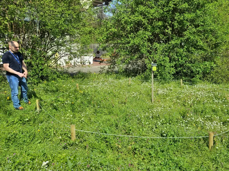
Biodiversity Net Gain · England
Statutory BNG, from the desk baseline to the biodiversity gain plan.
Schedule 7A to the Town and Country Planning Act 1990 asks a development in England to leave biodiversity at least 10 per cent above its pre-development value, and the statutory metric applies that to each type of unit. Here you see how the desk baseline and the inputs of the metric are prepared, page by page.
We prepare the baseline and the inputs; a competent person runs the statutory metric tool and the local planning authority approves the plan.
The XNatura AI assistant answers straight away and books the call for you.
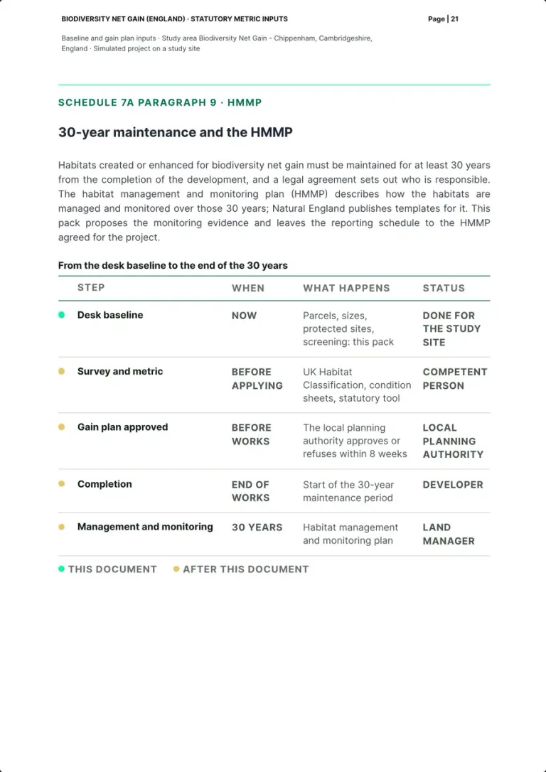
From the desk baseline to the end of the 30 years
Five steps to a biodiversity gain plan. We prepare the first.
Desk baseline
Red line, candidate parcels and their sizes, protected sites and priority habitat screening, from the platform's data: the pack on this page.
The pack below
Survey and metric
A UK Habitat Classification survey and the condition sheets, then the statutory metric tool, the only place where biodiversity units are calculated.
User guide, Principle 1 and Rule 3
Gain plan approved
The local planning authority approves or refuses the biodiversity gain plan within 8 weeks, and development cannot begin before approval.
Schedule 7A, paragraphs 13 to 15
Completion
The end of the works starts the 30-year maintenance period of the habitats created or enhanced.
Schedule 7A, paragraph 9
Management and monitoring
The habitats are managed and monitored under the habitat management and monitoring plan (HMMP), with the reporting schedule agreed for the project.
GOV.UK, Register a biodiversity gain site
The pack, page by page
From the fact sheet to the sources, with no units.
The pages are real: they come from a pack generated with the platform from a template for the statutory metric, on a real study site at Chippenham, Cambridgeshire, 6 m from Chippenham Fen and Snailwell Poor's Fen SSSI. The development is simulated: no developer, no client, no planning application, no survey. Biodiversity units are calculated with the statutory biodiversity metric tool (Rule 3 of the user guide), so the pack shows none: it prepares the inputs. For each section: what the law or the guidance asks, how the pack shows it and who does it.
Biodiversity Net Gain (England), baseline and biodiversity gain plan inputs, generated with the platform, study site at Chippenham, Cambridgeshire · 25 numbered pages plus the cover, PDF not public
Where each section comes from
- Measured by the platform
- Prepared by our team
- Left to the competent person
8 sections out of 22 measured by the platform, 14 prepared by our team from the law and the guidance. The survey, condition and the metric are left to the competent person; the local planning authority approves the plan.
The pack01 / 22
The pack's fact sheet
- Measured by the platform
- Prepared by our team
What the law or the guidance asks
The statutory metric is used only in its calculation tool, today version 1.0.4 with the user guide of June 2026; versions 4.0 or earlier are not accepted (Rule 3; GOV.UK, Statutory biodiversity metric tools and guides).
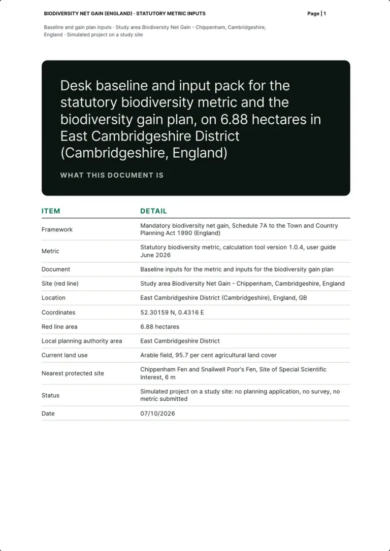
How the pack shows it
One table: the framework, the metric (calculation tool version 1.0.4, user guide June 2026), a red line of 6.88 hectares in East Cambridgeshire District at 52.30159 N, 0.4316 E, an arable field with 95.7 per cent agricultural land cover, Chippenham Fen and Snailwell Poor's Fen SSSI at 6 m. The status row says it: a simulated project, no planning application, no survey, no metric submitted.
Who does it XNatura platform and team
Real page · simulated project on a study site · p. 1/25 The pack02 / 22
Summary: what the pack does, and what it does not
- Prepared by our team
- Measured by the platform
What the law or the guidance asks
The biodiversity value attributable to the development must exceed the pre-development value of the on-site habitat by at least 10 per cent (Schedule 7A, paragraph 2), for each type of unit (Rule 2).
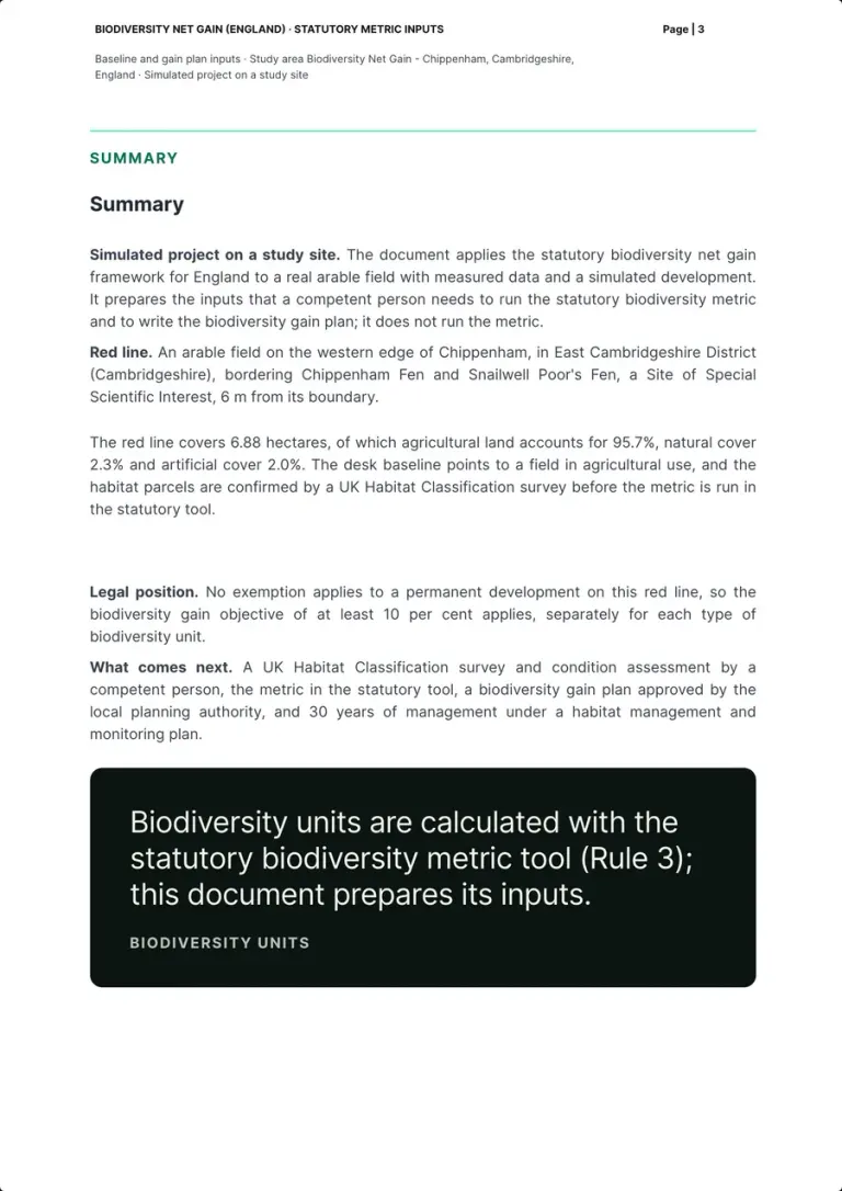
How the pack shows it
The pack prepares the inputs a competent person needs and does not run the metric. The red line covers 6.88 hectares, 95.7% agricultural, 2.3% natural and 2.0% artificial, 6 m from the SSSI. No exemption applies, so the 10 per cent objective applies to each type of unit; next come the survey, the statutory tool, the gain plan and 30 years of management. A dark box closes the page with Rule 3.
Who does it Our team, on the platform's data
Real page · simulated project on a study site · p. 3/25 The framework03 / 22
The legal frame and its milestones
- Prepared by our team
What the law or the guidance asks
Development may not begin until a biodiversity gain plan has been submitted to and approved by the planning authority (Schedule 7A, paragraphs 13 to 15); significant on-site enhancements count only if maintained for at least 30 years (paragraph 9).
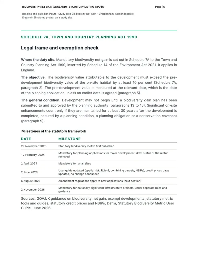
How the pack shows it
Where the duty sits (Schedule 7A, inserted by Schedule 14 of the Environment Act 2021), the objective, the relevant date and the general condition; then the milestones: the metric first published on 29 November 2023, mandatory for major development from 12 February 2024 and for small sites from 2 April 2024, the user guide updated on 2 June 2026, the amendment regulations from 6 August 2026, nationally significant infrastructure projects from 2 November 2026 under separate rules.
Who does it Our team, on the statute and the guidance
Real page · simulated project on a study site · p. 5/25 The framework04 / 22
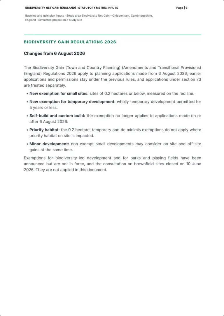
What changed on 6 August 2026
- Prepared by our team
What the law or the guidance asks
From 6 August 2026 sites of 0.2 hectares or below and wholly temporary development permitted for 5 years or less are exempt, and the self-build and custom build exemption no longer applies to new applications (GOV.UK, Biodiversity net gain: exempt developments).
How the pack shows it
The Biodiversity Gain Regulations 2026 apply to applications made from 6 August 2026, with section 73 treated separately: a new exemption for sites of 0.2 hectares or below on the red line, one for temporary development permitted for 5 years or less, self-build no longer exempt, and neither new exemption nor de minimis where priority habitat on site is impacted. Exemptions announced but not in force, and the brownfield consultation closed on 10 June 2026, are not applied.
Who does it Our team, on the regulations
Real page · simulated project on a study site · p. 6/25 The framework05 / 22
The exemption check
- Prepared by our team
- Measured by the platform
- Left to the competent person
What the law or the guidance asks
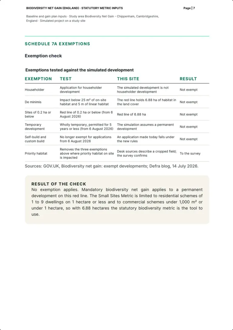
Exempt are householder applications, de minimis impacts under 25 m² of on-site habitat or 5 m of linear habitat, red lines of 0.2 hectares or below and temporary development; the last three not where priority habitat on site is impacted (GOV.UK, Biodiversity net gain: exempt developments).
How the pack shows it
Six exemptions tested against the simulated development: householder, de minimis (25 m² and 5 m), 0.2 ha, temporary (5 years), self-build, priority habitat. With a red line of 6.88 ha none applies, and priority habitat goes to the survey. The Small Sites Metric stops at 1 to 9 dwellings on 1 hectare or less and commercial schemes under 1,000 m², so the statutory metric is the tool to use.
Who does it Our team; priority habitat left to the survey
Real page · simulated project on a study site · p. 7/25 The site06 / 22
Red line and control area
- Measured by the platform
What the law or the guidance asks
The pre-development value is that of the on-site habitat, measured at the relevant date (Schedule 7A, paragraphs 2 and 5).
How the pack shows it
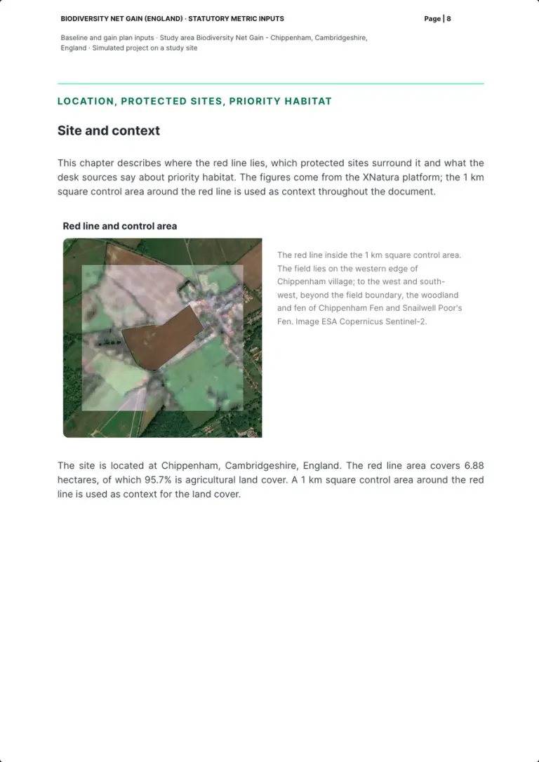
The red line on a Sentinel-2 image, inside the 1 km square control area used as context throughout the pack: an arable field of 6.88 hectares on the western edge of Chippenham village, 95.7% agricultural land cover, with the woodland and fen of Chippenham Fen and Snailwell Poor's Fen beyond its western boundary.
Who does it XNatura platform
Real page · simulated project on a study site · p. 8/25 The site07 / 22
Protected sites within 5 km
- Measured by the platform
What the law or the guidance asks
The Small Sites Metric cannot be used where priority habitat, protected sites or European protected species are involved (GOV.UK, Biodiversity metric: the small sites metric).
How the pack shows it
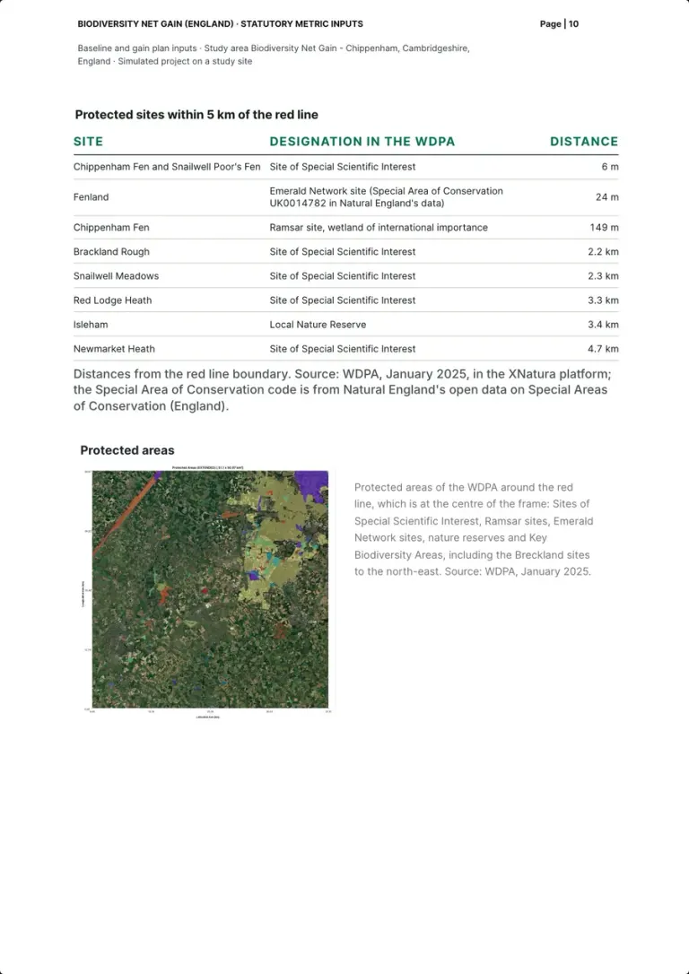
The protected sites of the World Database on Protected Areas (January 2025) within 5 km of the red line, with designation and distance from the boundary: Chippenham Fen and Snailwell Poor's Fen SSSI at 6 m, Fenland at 24 m (Special Area of Conservation UK0014782 in Natural England's data), the Chippenham Fen Ramsar site at 149 m, then Sites of Special Scientific Interest and a Local Nature Reserve between 2.2 and 4.7 km. A map frames them around the red line.
Who does it XNatura platform
Real page · simulated project on a study site · p. 10/25 The site08 / 22
Priority habitat screening
- Measured by the platform
- Left to the competent person
What the law or the guidance asks
Where priority habitat on site is impacted, the 0.2 hectare, temporary and de minimis exemptions do not apply and the Small Sites Metric cannot be used (GOV.UK, Biodiversity net gain: exempt developments; the small sites metric).
How the pack shows it
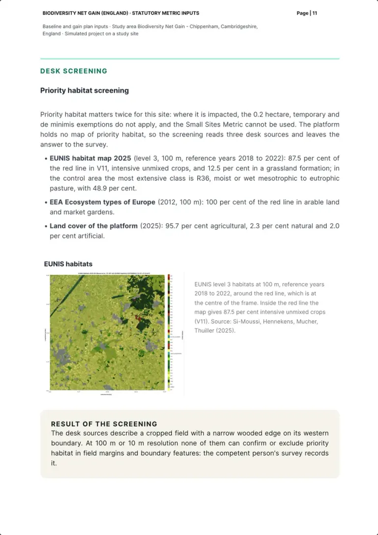
The platform holds no map of priority habitat, so the screening reads three desk sources: the EUNIS habitat map 2025 (level 3, 100 m, 2018 to 2022) puts 87.5 per cent of the red line in intensive unmixed crops (V11) and 12.5 in a grassland formation; the EEA ecosystem types (2012) 100 per cent arable; the platform's land cover 95.7 per cent agricultural. At 100 m or 10 m none can confirm or exclude priority habitat in field margins: the competent person's survey records it.
Who does it XNatura platform; the survey records it
Real page · simulated project on a study site · p. 11/25 Baseline inputs09 / 22
What the metric takes
- Prepared by our team
- Left to the competent person
What the law or the guidance asks
The metric values each habitat parcel by its size, condition, strategic significance and distinctiveness (GOV.UK, What the biodiversity metric is), and the units are calculated only in the statutory tool (Rule 3, Table 2, p.15).
How the pack shows it
The chapter opens with the four inputs of each parcel, size, distinctiveness, condition and strategic significance (user guide p.26), and the definition of a habitat parcel (Table 1, p.12): area habitats in hectares, hedgerows and watercourses in kilometres in their own modules. A box states Rule 3: the tool calculates the units and says whether the objective is met (Table 2, p.15). The platform's land cover, down to 10 m with reference year 2025, gives the outline and size of the parcels, not the habitat type (p.27).
Who does it Our team, on the user guide
Real page · simulated project on a study site · p. 12/25 Baseline inputs10 / 22
Land cover of the control area
- Measured by the platform
What the law or the guidance asks
A habitat parcel is a linked area of habitat of the same distinctiveness, condition and strategic significance (Table 1, p.12), and a professional survey is required to determine habitat type (p.27).
How the pack shows it
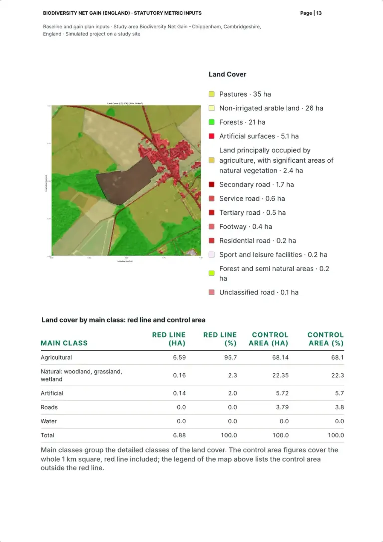
The land cover map of the 1 km control area with the red line at its centre and a legend by class, from 35 ha of pastures and 26 of non-irrigated arable land to 21 of forests. The table by main class: the red line is 6.59 ha agricultural (95.7%), 0.16 natural (2.3%) and 0.14 artificial (2.0%), with no water; the control area is 68.1% agricultural and 22.3% natural.
Who does it XNatura platform
Real page · simulated project on a study site · p. 13/25 Baseline inputs11 / 22
Candidate parcels inside the red line
- Measured by the platform
- Left to the competent person
What the law or the guidance asks
Habitat types come from the UK Habitat Classification (Table 1, p.12); distinctiveness follows the habitat type, and condition is assessed with the metric's condition sheets (p.27 and p.28).
How the pack shows it
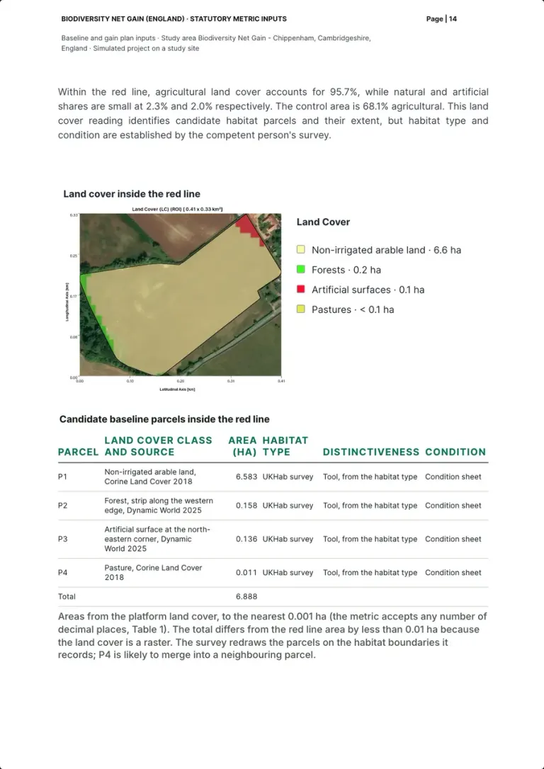
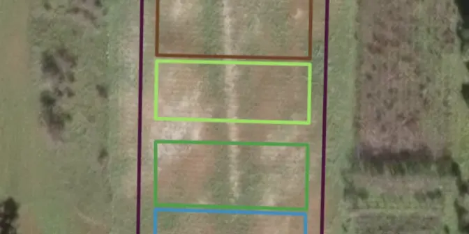
The land cover inside the red line and four candidate parcels drawn from it: P1 non-irrigated arable land, 6.583 ha (Corine Land Cover 2018); P2 a forest strip on the western edge, 0.158 ha, and P3 an artificial surface at the north-eastern corner, 0.136 ha (Dynamic World 2025); P4 pasture, 0.011 ha. Total 6.888 ha. For each, habitat type goes to the UKHab survey, distinctiveness to the tool, condition to the condition sheet.
Who does it XNatura platform; habitat type and condition by the survey
Real page · simulated project on a study site · p. 14/25 Baseline inputs12 / 22
How each input is filled, and distinctiveness
- Prepared by our team
- Left to the competent person
What the law or the guidance asks
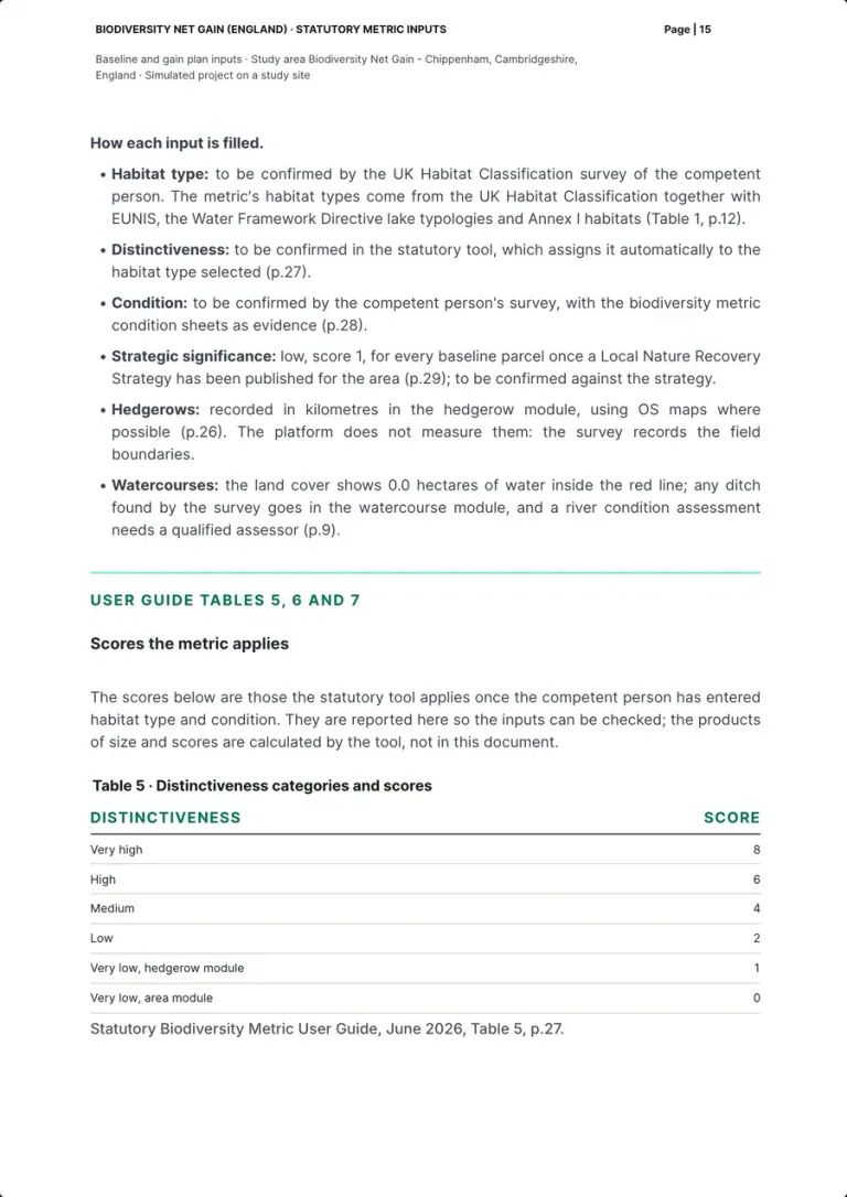
Distinctiveness scores: very high 8, high 6, medium 4, low 2, very low 1 in the hedgerow module and 0 in the area module (Table 5, p.27).
How the pack shows it
Input by input: habitat type from the UK Habitat Classification survey; distinctiveness set by the tool from the habitat type (p.27); condition from the survey with the condition sheets (p.28); strategic significance low, score 1, once a Local Nature Recovery Strategy is published (p.29); hedgerows not measured by the platform; 0.0 hectares of water, any ditch to the watercourse module (p.9). Then Table 5, scores from 8 to 0, which the tool applies: the products of size and scores are the tool's, not the pack's.
Who does it Our team, on the user guide; values by the competent person and the tool
Real page · simulated project on a study site · p. 15/25 Baseline inputs13 / 22
Condition and strategic significance
- Prepared by our team
- Left to the competent person
What the law or the guidance asks
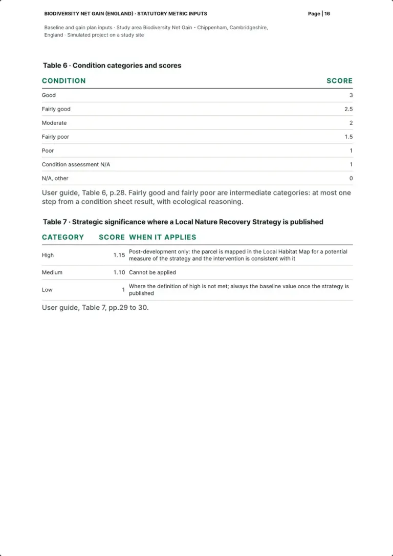
Condition scores: good 3, fairly good 2.5, moderate 2, fairly poor 1.5, poor 1, condition assessment N/A 1, N/A other 0 (Table 6, p.28). Strategic significance: high 1.15 only where parcel and intervention match a mapped measure of the published strategy, medium 1.10 cannot be applied, low 1 (Table 7, pp.29 to 30).
How the pack shows it
Table 6 gives the condition scores from 3 to 0, the intermediate categories at most one step from a condition sheet result. Table 7 gives strategic significance where a Local Nature Recovery Strategy is published: 1.15 post-development only, where the parcel is mapped in the Local Habitat Map for a measure of the strategy; 1.10 cannot be applied; 1 otherwise, always the baseline value.
Who does it Our team, on the user guide; condition by the competent person
Real page · simulated project on a study site · p. 16/25 Baseline inputs14 / 22
Imagery record and the relevant date
- Measured by the platform
- Prepared by our team
What the law or the guidance asks
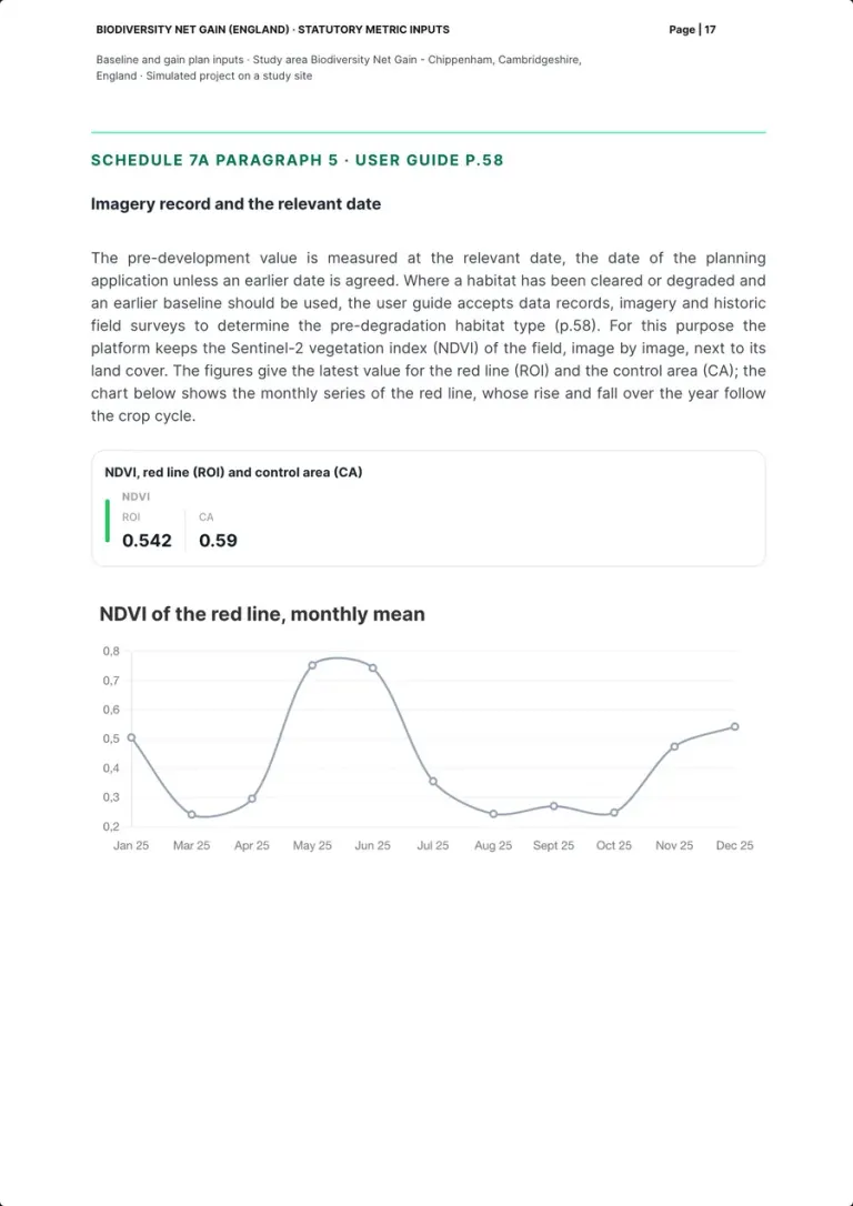
The pre-development value is measured at the relevant date, the application date unless an earlier one is agreed (Schedule 7A, paragraph 5); where habitat has been degraded, data records and imagery can inform the earlier baseline (p.58).
How the pack shows it
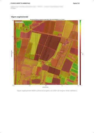
The platform keeps the Sentinel-2 vegetation index of the field image by image, next to its land cover: the latest NDVI is 0.542 for the red line and 0.59 for the control area, and the monthly series of the red line, from January to December, rises and falls with the crop cycle.
Who does it XNatura platform, read by our team
Real page · simulated project on a study site · p. 17/25 The objective15 / 22
The 10% objective for each unit type
- Prepared by our team
- Left to the competent person
What the law or the guidance asks
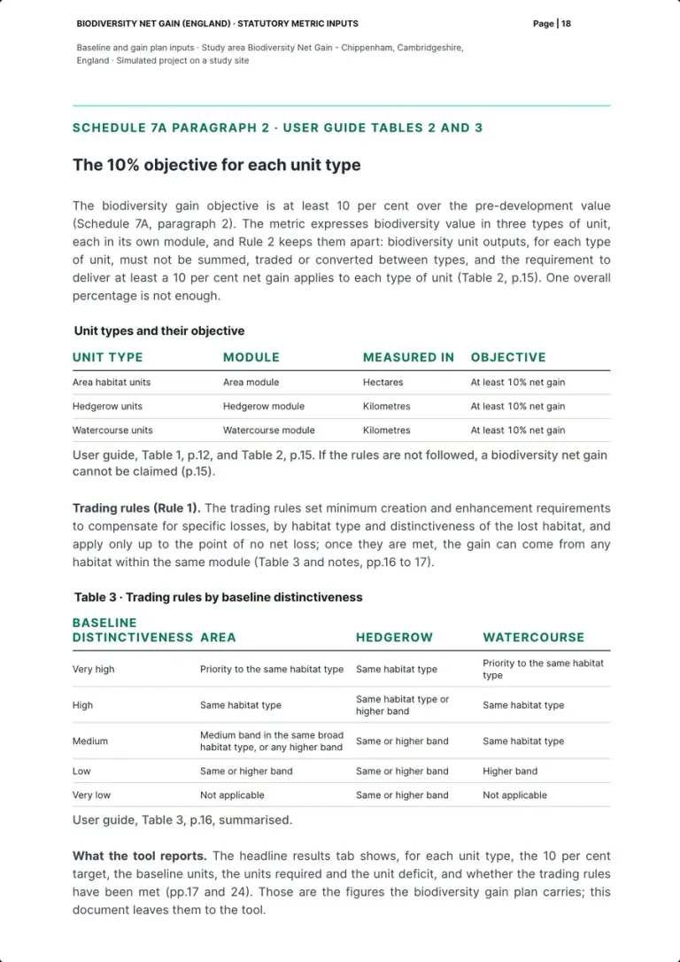
Area habitat, hedgerow and watercourse units each need their own net gain of at least 10 per cent, and must not be summed, traded or converted between types (Rule 2, Table 2, p.15); trading rules set minimum replacements by distinctiveness, up to the point of no net loss (Rule 1, Table 3, pp.16 to 17).
How the pack shows it
Three unit types, each in its own module, area habitats in hectares, hedgerows and watercourses in kilometres, each with an objective of at least 10% net gain: one overall percentage is not enough. Table 3 summarises the trading rules by baseline distinctiveness. The tool's headline results show, for each unit type, the target, the baseline units, the units required and the deficit (pp.17 and 24): the gain plan carries those figures, the pack leaves them to the tool.
Who does it Our team; the tool reports the result
Real page · simulated project on a study site · p. 18/25 Delivery16 / 22
Delivery options and the register
- Prepared by our team
What the law or the guidance asks
Gains come on-site first, then from off-site units, and from statutory credits only as a last resort; off-site gains must be recorded on the biodiversity gain sites register run by Natural England (GOV.UK, Understanding biodiversity net gain; Register a biodiversity gain site).
How the pack shows it
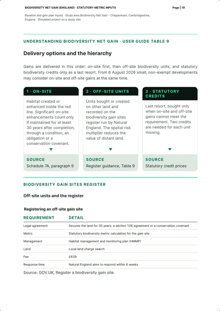
Three cards in order: on-site, where significant enhancements count only if maintained for at least 30 years after completion; off-site units recorded on the register, distant land reduced by the spatial risk multiplier; statutory credits as the last resort, two for each unit missing. Then what registering an off-site gain site takes: a legal agreement securing the land for 30 years (section 106 or conservation covenant), the metric calculation, the HMMP, a local land charge search and a fee of £639; Natural England aims to respond within 6 weeks.
Who does it Our team, on the GOV.UK guidance
Real page · simulated project on a study site · p. 19/25 Delivery17 / 22
Spatial risk and statutory credits
- Prepared by our team
What the law or the guidance asks
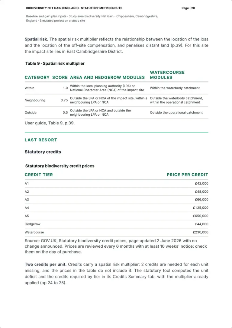
Off-site land is weighted by the spatial risk multiplier, 1.0 within the local planning authority or National Character Area, 0.75 neighbouring, 0.5 outside (Table 9, p.39); statutory credits are priced per tier and 2 credits are needed for each unit missing (GOV.UK, Statutory biodiversity credit prices).
How the pack shows it
Table 9 with the multiplier, 1.0, 0.75 and 0.5, for the area and hedgerow modules and by catchment for watercourses, the impact site in East Cambridgeshire District. Then the credit prices of the page updated 2 June 2026: A1 £42,000, A2 £48,000, A3 £66,000, A4 £125,000, A5 £650,000, hedgerow £44,000, watercourse £230,000, reviewed every 6 months with at least 10 weeks' notice. The multiplier of 2 credits per unit missing is not in the prices: the tool's Credits Summary applies it (pp.24 to 25).
Who does it Our team, on the GOV.UK guidance and the user guide
Real page · simulated project on a study site · p. 20/25 Plan and monitoring18 / 22
30-year maintenance and the HMMP
- Prepared by our team
What the law or the guidance asks
Habitats created or enhanced must be maintained for at least 30 years from completion, under a legal agreement; the habitat management and monitoring plan (HMMP) describes how, and Natural England publishes templates (GOV.UK, Understanding biodiversity net gain; Schedule 7A, paragraph 9).
How the pack shows it
The HMMP over the 30 years, and the table from the desk baseline to the end of the 30 years: the desk baseline now, done for the study site; survey and metric before applying, by the competent person; the gain plan approved before works, by the local planning authority within 8 weeks; completion, which starts the 30-year period; management and monitoring by the land manager. The pack proposes the monitoring evidence and leaves the reporting schedule to the HMMP.
Who does it Our team; the land manager over the 30 years
Real page · simulated project on a study site · p. 21/25 Plan and monitoring19 / 22
The biodiversity gain plan
- Prepared by our team
- Left to the competent person
What the law or the guidance asks
The biodiversity gain plan goes to the local planning authority, which must approve or refuse it within 8 weeks; it carries the metric calculation, pre- and post-development plans, register references, proof of credits and how significant on-site gains are managed and monitored (Schedule 7A, paragraph 15; GOV.UK, Submit a biodiversity gain plan).
How the pack shows it
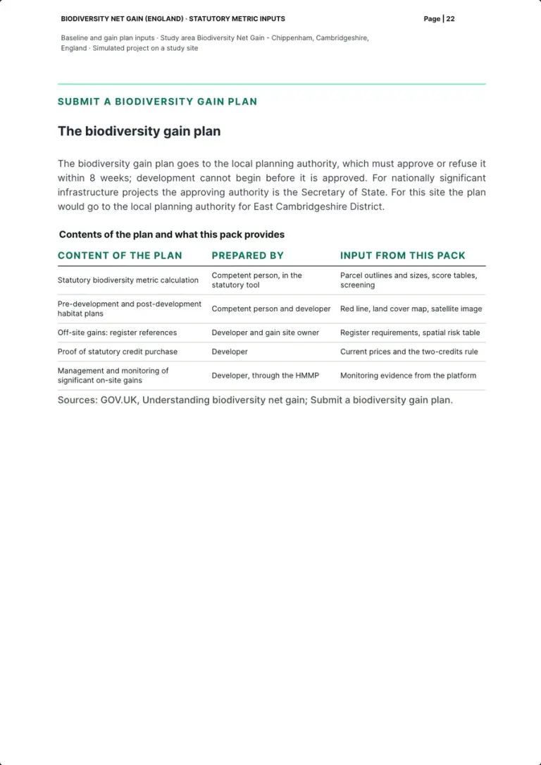
Who approves: the local planning authority within 8 weeks, the Secretary of State for nationally significant infrastructure projects, here the authority for East Cambridgeshire District. Then a table of the plan's contents, who prepares each and what this pack provides: parcel outlines, sizes, score tables and screening for the metric; red line, land cover map and satellite image for the habitat plans; register requirements and the spatial risk table; current prices and the two-credits rule; monitoring evidence from the platform.
Who does it Developer with the competent person; the local planning authority decides
Real page · simulated project on a study site · p. 22/25 Plan and monitoring20 / 22
Who does what
- Prepared by our team
What the law or the guidance asks
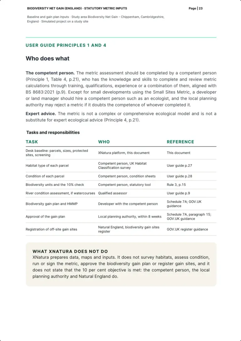
The metric assessment should be completed by a competent person (Principle 1, p.21), with competence aligned with BS 8683:2021 (p.9); the metric is not a substitute for expert ecological advice (Principle 4, p.21).
How the pack shows it
The tasks with who does them and the reference: the desk baseline by the platform; habitat type, condition, the units and the 10% check by the competent person; river condition by a qualified assessor; the gain plan and the HMMP by the developer with the competent person; approval by the local planning authority within 8 weeks; off-site registration by Natural England. A box says what XNatura does not do: survey habitats, assess condition, run or sign the metric, approve the plan, register gain sites, or state that the objective is met.
Who does it Our team, on the user guide
Real page · simulated project on a study site · p. 23/25 Plan and monitoring21 / 22
Monitoring with the platform
- Measured by the platform
- Left to the competent person
What the law or the guidance asks
The HMMP describes how the habitats are managed and monitored over the 30 years (GOV.UK, Register a biodiversity gain site; Submit a biodiversity gain plan).
How the pack shows it
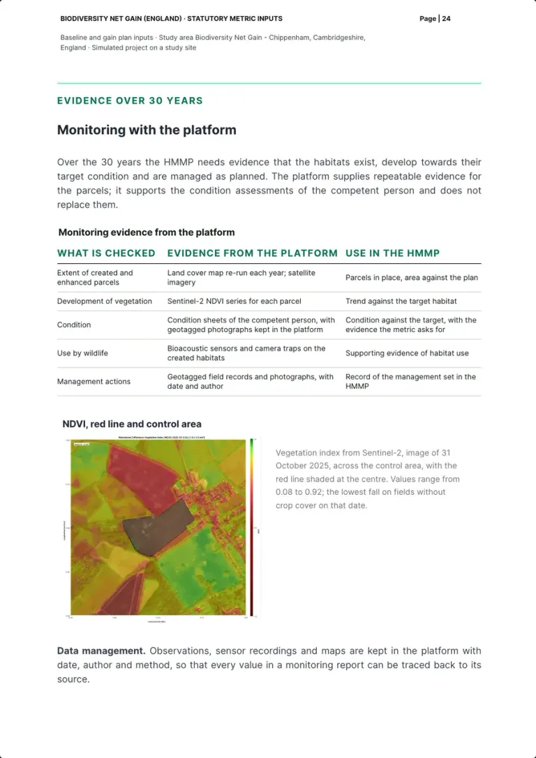
What the HMMP needs over 30 years and the evidence the platform supplies: land cover and satellite imagery for the extent of the parcels, the Sentinel-2 NDVI series for vegetation, the competent person's condition sheets with geotagged photographs, bioacoustic sensors and camera traps for use by wildlife, geotagged field records for management. The NDVI map of the control area, image of 31 October 2025, ranges from 0.08 to 0.92. The platform supports the competent person's condition assessments and does not replace them.
Who does it XNatura platform; condition by the competent person
Real page · simulated project on a study site · p. 24/25 Method22 / 22
Method, sources and limits
- Prepared by our team
What the law or the guidance asks
A professional survey is required to determine habitat type (p.27), and biodiversity units are calculated only in the statutory tool (Rule 3, p.15).
How the pack shows it
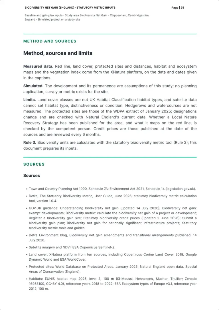
Measured data set apart from assumptions, and the limits: land cover classes are not UK Habitat Classification types, satellite data cannot set habitat type, distinctiveness or condition, hedgerows and watercourses are not measured, the protected sites are those of the WDPA extract of January 2025, credit prices are reviewed every 6 months. Then the sources, from Schedule 7A and the user guide of June 2026 (tool version 1.0.4) to the GOV.UK guidance, the Defra blog of 14 July 2026 and the datasets.
Who does it Our team
Real page · simulated project on a study site · p. 25/25
How the desk baseline is drawn
Parcels and sizes from the land cover. Habitat type from the survey.
The platform measures the red line and its 1 km control area: land cover by class with the hectares of each, protected sites with their distance, the vegetation index image by image. It gives the competent person a starting outline of the parcels and their size, which the survey then confirms or redraws.
Satellites and datasets
Open imagery and maps, updated over time.
One class per pixel
The platform's land cover combines ten sources, with pixels down to 10 metres.
4 candidate parcels
Drawn from the land cover of the red line, each with its size to the nearest 0.001 ha.
The competent person's survey
A UK Habitat Classification survey and the condition sheets give habitat type and condition; the statutory tool turns the inputs into units.
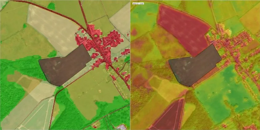
Same area, two layers
Switch the layer, the red line stays put.
The two maps come from the pack above, pages 13 and 24, cropped to the same scale: the 1 km control area with the red line shaded at its centre. Land cover gives classes and hectares; the vegetation index records the field image by image, as monitoring evidence.

Land Use 
Natural Habitat Coverage 
Impervious Land Ratio 
Built-Up Surface 
Water Coverage 
Protected Areas 
Observations
Indicator cards of the XNatura platform, from the site's Satellite maps page. The platform's satellite maps
In the field with Biodiversa
The satellite gives the parcels. The field gives the evidence.
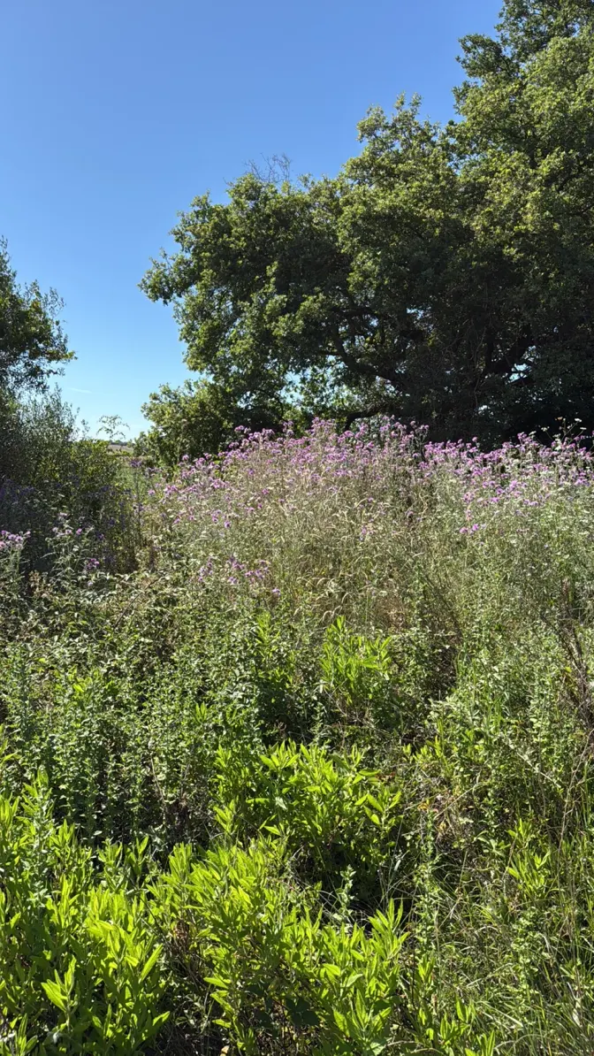
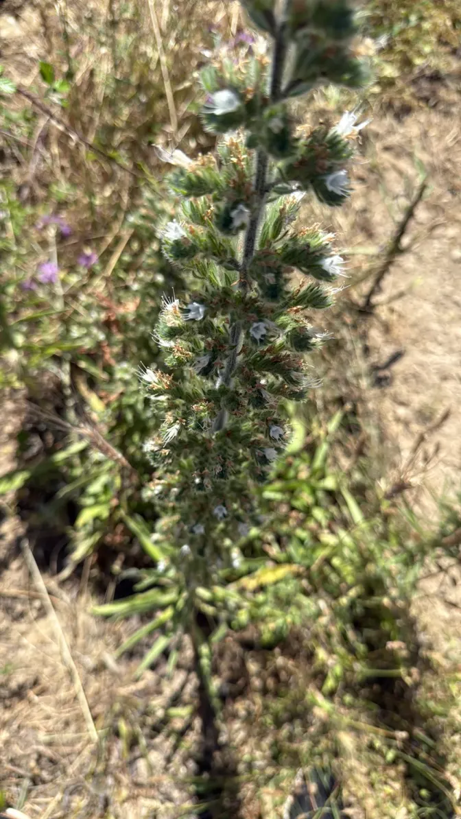
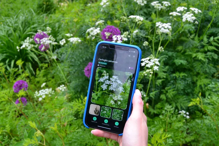
Over the 30 years the HMMP needs evidence that the habitats exist, develop and are managed as planned. Field records are made with the Biodiversa app: every observation with its species, position and photo, straight into the platform, next to the competent person's condition sheets.
- FieldSurvey with the app
- CheckValidated by the expert
- DataCensus observations
- ReportThe record shows up in the report

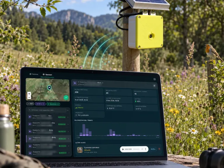
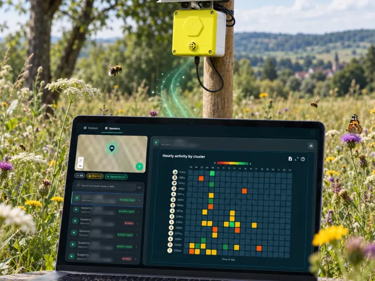
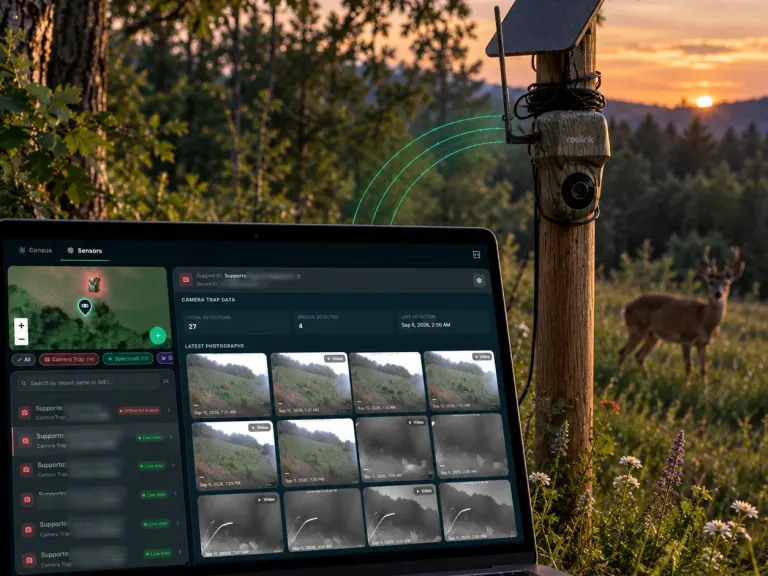
Bioacoustic sensors and camera traps
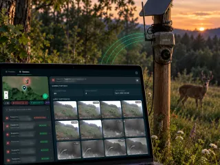
On the habitats created or enhanced they record use by wildlife, continuously and without disturbance: supporting evidence for the HMMP, which the platform keeps with date, author and method.
The pack, p. 24: supporting evidence of habitat use
The Nature Experts
We prepare the inputs. The competent person runs the metric.
The metric assessment should be completed by a competent person (Principle 1 of the user guide), and the metric is not a substitute for expert ecological advice (Principle 4). Our Nature Experts prepare the desk baseline, the inputs and the monitoring evidence for the competent person the developer hires.
- 01PrepareRed line, parcels, sizes, protected sites and screening from the platform
- 02ExplainThe framework, the exemptions, the objective and delivery, each with its source
- 03MonitorRepeatable evidence for the HMMP over the 30 years
- 40+in-house nature, climate and ESG specialists
- 7disciplines under one roof
- 10years of track record
Who works on a biodiversity gain plan
Our team
Prepares the desk baseline and the metric inputs on the platform's data, and the monitoring evidence. It does not survey, run or sign the metric.
Competent person
Surveys the habitats with the UK Habitat Classification, assesses condition with the condition sheets and runs the statutory metric tool.
Developer
Submits the biodiversity gain plan and the HMMP, with a legal agreement that sets who is responsible over the 30 years.
Local planning authority
Approves or refuses the biodiversity gain plan within 8 weeks; development cannot begin before approval.
Natural England
Runs the biodiversity gain sites register, where off-site gains are recorded.
The team's disciplines
 Ecology & biodiversityBiologists, zoologists, environmental scientists: baselines, surveys, camera traps, bioacoustics, telemetry.
 Assessment, reporting & complianceESRS E4, BNG, SBTN, GRI, EIA/SEA, VIncA, BREEAM/LEED. Board- and authority-ready.
 Agronomy & land useRegenerative agriculture, supply chains, land and vegetation management.
 Data & remote sensingGIS, satellite analysis, IoT data, predictive models, digital twinning.
 Climate & riskIPCC scenarios, physical risk, wildfire and water modelling per asset.
 Strategy & deliveryNature strategy, action plans, green finance, stakeholder engagement, client training.

Delivery
On-site first, off-site next, statutory credits last.
Gains are delivered in this order. From 6 August 2026 small, non-exempt developments may consider on-site and off-site gains at the same time.
On-site
Habitat created or enhanced inside the red line. Significant on-site enhancements count only if maintained for at least 30 years after completion, secured by a planning condition, a planning obligation or a conservation covenant.
Schedule 7A, paragraph 9
Off-site units
Units bought or created on other land and recorded on the biodiversity gain sites register run by Natural England. Registration needs a legal agreement securing the land for 30 years, the metric calculation, the HMMP and a local land charge search; the fee is £639, and Natural England aims to respond within 6 weeks. Distant land counts less: the spatial risk multiplier is 1.0 within the local planning authority or National Character Area, 0.75 neighbouring, 0.5 outside.
GOV.UK, Register a biodiversity gain site; user guide, Table 9, p.39
Statutory credits
The last resort, bought only when on-site and off-site gains cannot meet the requirement. Two credits are needed for each unit missing, and the prices below do not include that multiplier.
GOV.UK, Statutory biodiversity credit prices
| Credit tier | Price per credit |
|---|---|
| A1 | £42,000 |
| A2 | £48,000 |
| A3 | £66,000 |
| A4 | £125,000 |
| A5 | £650,000 |
| Hedgerow | £44,000 |
| Watercourse | £230,000 |
As published on the GOV.UK page updated 2 June 2026, with no change announced. Prices are reviewed every 6 months with at least 10 weeks' notice: check them on the day of purchase.
The voice that guides you through the pack
Ask, and the page takes you there.
A voice assistant always within reach, bottom right. Ask it about a section of the pack, the 10 per cent objective or who does what: it answers and brings the page to the right point.
- It answers about this page: statutory Biodiversity Net Gain in England, the path to the gain plan, what each section of the pack shows.
- It walks you through the document: it scrolls to the section and highlights it while you keep talking.
- If you want a first analysis of your site on the platform, it prepares it, and you open it on XNatura after signing in.
You can ask, for example
- Take me to the exemption check
- What does the metric take for each parcel?
- Who calculates the biodiversity units?
- What are statutory credits?
- I'd like a first analysis of my site on the platform
Contact
A planning application in England to prepare?
Tell us about the site, the development and your timing. A named strategist replies within 24 working hours.
30 minutes with the XNatura team
Video call on Google Meet
Would you rather talk it through?
Either way you are speaking with an AI assistant, and the conversation is transcribed. How we handle your data
Tell us about the site
Request sent.
One of our strategists replies within 24 working hours. If you need us sooner, write to info@3bee.com.
Our systems are temporarily unreachable and the request did not go through. Try again, or write to info@3bee.com.
We could not verify that the request comes from a person, so it was not sent. Reload the page and try again. You can also write to info@3bee.com or call +39 030 204 1767.
FAQ
Frequently asked questions on Biodiversity Net Gain
What is mandatory Biodiversity Net Gain?
In England, Schedule 7A to the Town and Country Planning Act 1990, inserted by the Environment Act 2021, asks a development to deliver a biodiversity value at least 10 per cent above the pre-development value of the on-site habitat, measured at the relevant date (paragraphs 2 and 5). It applies to planning applications made from 12 February 2024 for major development and from 2 April 2024 for small sites; nationally significant infrastructure projects follow separate rules and guidance from 2 November 2026.
Which developments are exempt?
Householder applications; de minimis impacts, under 25 m² of on-site habitat or 5 m of linear habitat; and, for applications made from 6 August 2026, sites of 0.2 hectares or below and wholly temporary development permitted for 5 years or less. Those last three do not apply where priority habitat on site is impacted, and the self-build and custom build exemption no longer applies to applications made on or after 6 August 2026.
Do you calculate the biodiversity units?
No. Biodiversity units are calculated with the statutory biodiversity metric tool (Rule 3 of the user guide), by a competent person such as an ecologist, who surveys the site with the UK Habitat Classification and assesses condition with the metric's condition sheets. We prepare the desk baseline and the inputs: red line, candidate parcels and their sizes, protected sites, priority habitat screening, the score tables, and then the monitoring evidence. The local planning authority approves the biodiversity gain plan.
Does the 10 per cent apply to each type of unit?
Yes. Area habitat, hedgerow and watercourse units each need their own net gain of at least 10 per cent, and they must not be summed, traded or converted between types (Rule 2): one overall percentage is not enough. Within a module, the trading rules set minimum replacements by distinctiveness, up to the point of no net loss (Rule 1).
What if the gain cannot be delivered on site?
On-site comes first, then off-site units recorded on the biodiversity gain sites register run by Natural England (a legal agreement securing the land for 30 years, a registration fee of £639), and statutory credits only as a last resort: 2 credits for each unit missing, at prices from £42,000 (A1) to £650,000 (A5) per credit, reviewed every 6 months. From 6 August 2026 small, non-exempt developments may consider on-site and off-site gains at the same time.
Who approves the biodiversity gain plan, and how long does it take?
The local planning authority, which must approve or refuse it within 8 weeks; development cannot begin before approval (Schedule 7A, paragraphs 13 to 15). For nationally significant infrastructure projects the approving authority is the Secretary of State. The habitats created or enhanced are then maintained for at least 30 years from completion, under a habitat management and monitoring plan.
Is the project on this page real?
The pack is real in its form: generated with the platform from a template for the statutory metric, on a real study site at Chippenham, Cambridgeshire. The development is simulated: no developer, no client, no planning application, no survey, no metric submitted, and no biodiversity units, which only the statutory tool calculates.
XNatura · AI
Voice assistant
Ask me about a section of the pack, the objective or who does what: I'll take you where you need to be.
You can ask, for example
- Take me to the exemption check
- What does the metric take for each parcel?
- Who calculates the biodiversity units?
- What are statutory credits?
- I'd like a first analysis of my site on the platform
You’ll speak with XNatura’s AI assistant. Your microphone only starts with your permission. You can review and confirm your details before sending a request. If the assistant prepares a demo for you, the site’s name and location go to the XNatura platform, which keeps them for one hour so you can open it. How we use your data
Getting your conversation ready…
The conversation
Start with a question or tell us what you need.
Your project updates as you speak
Review and send your request