









BREEAM · Land Use & Ecology
The BREEAM ecology report, page by page.
The site read from satellite, the field survey with Biodiversa, the ecological indicators and the actions with their KPIs: data measured, read and signed by our experts, in support of the qualified ecologist.
The XNatura AI assistant answers straight away and books the call for you.
The report, page by page
From the credit's question to the proposed answer.
The pages are real: they come from two delivered BREEAM In-Use V6 reports, the same ones you can download below. Site name, location and signatures have been removed and the maps are blurred. Each page stays in the language it was delivered in: the LUE 02 report in English, the LUE 03 report in Italian. For each section: what the credit asks for, how we produce it and who does it.
BREEAM In-Use V6 LUE 02 report, planted areas of a shopping centre in France, in English · 22 pages, PDF to download below
BREEAM In-Use V6 LUE 03 report, Ecology Survey of a shopping centre in Italy, in Italian · 15 pages, PDF to download below
Where each section comes from
- From the platform
- From the team, in the field and on the data
3 sections out of 20 come from the platform, 17 from the field survey and the team's reading. The BREEAM assessor chooses the credit's answer.
The credit01 / 20
LUE 02: the question
- From the team, in the field and on the data
What the credit asks for
Which ecological features have been planted or installed in the asset's planted areas? The assessor picks a single answer, from A to E.
How we produce it
The report opens with the question and the credit scale as BREEAM In-Use words them, and closes with the proposed answer and the evidence behind it.
Who does it Team ecologist
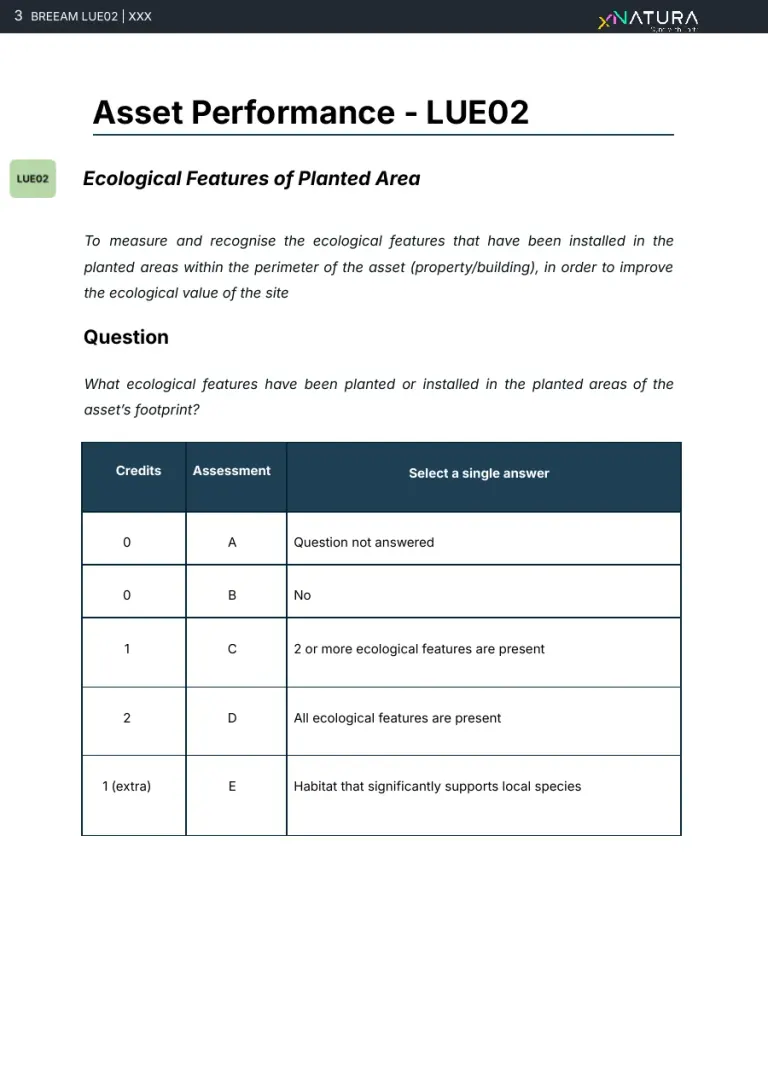
Real page · LUE 02, delivered report, anonymised · p. 3/22Download the report The credit02 / 20
The assessment criteria
- From the team, in the field and on the data
What the credit asks for
Five criteria: the types of ecological feature, native or pollinator-friendly species, features for wildlife, maintenance, and the exemplary level for habitat that supports local species.
How we produce it
For each criterion the report states the applicable answer, so the assessor sees at once what is there and what is missing.
Who does it Team ecologist
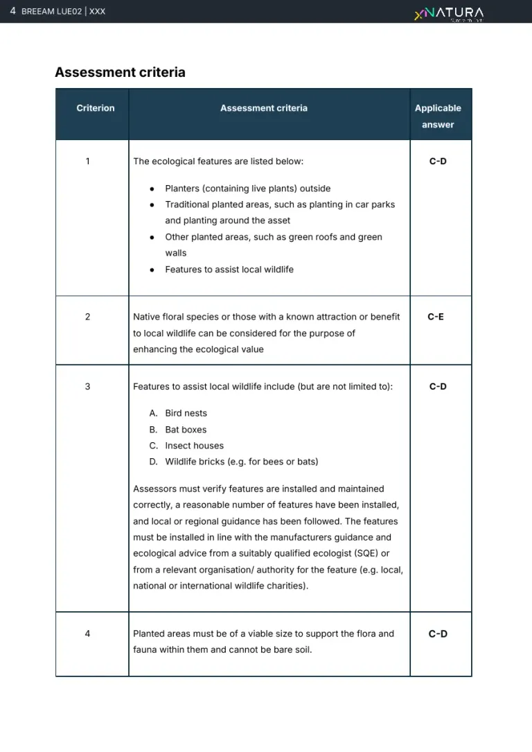
Real page · LUE 02, delivered report, anonymised · p. 4/22Download the report The site03 / 20
The site and its area of influence
- From the platform
What the credit asks for
Frame the asset: what is there, how large it is, which ecological and climatic context it sits in.
How we produce it
The platform frames the site: about 13 hectares, 9.6 of them used by people (73.7 per cent), the ecosystem under the Global Ecosystem Typology and the climate zone.
Who does it Platform
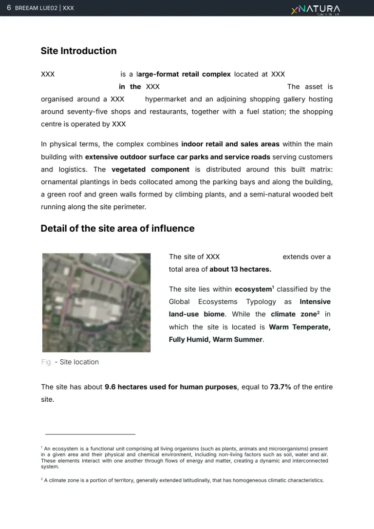
Real page · LUE 02, delivered report, anonymised · p. 6/22Download the report The site04 / 20
Land use, site and surroundings
- From the platform
What the credit asks for
How much of the site is artificial, agricultural, natural, water or road, and how it compares with the surrounding area.
How we produce it
Land-cover classes from satellite on 10 metre pixels, validated by an operator: 56.6 per cent artificial and 26.2 natural on the site, against 65.8 natural in the surroundings.
Who does it Platform, validated by an operator
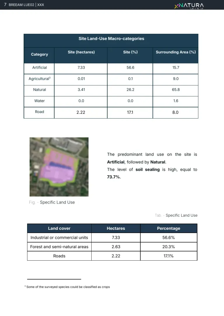
Real page · LUE 02, delivered report, anonymised · p. 7/22Download the report The site05 / 20
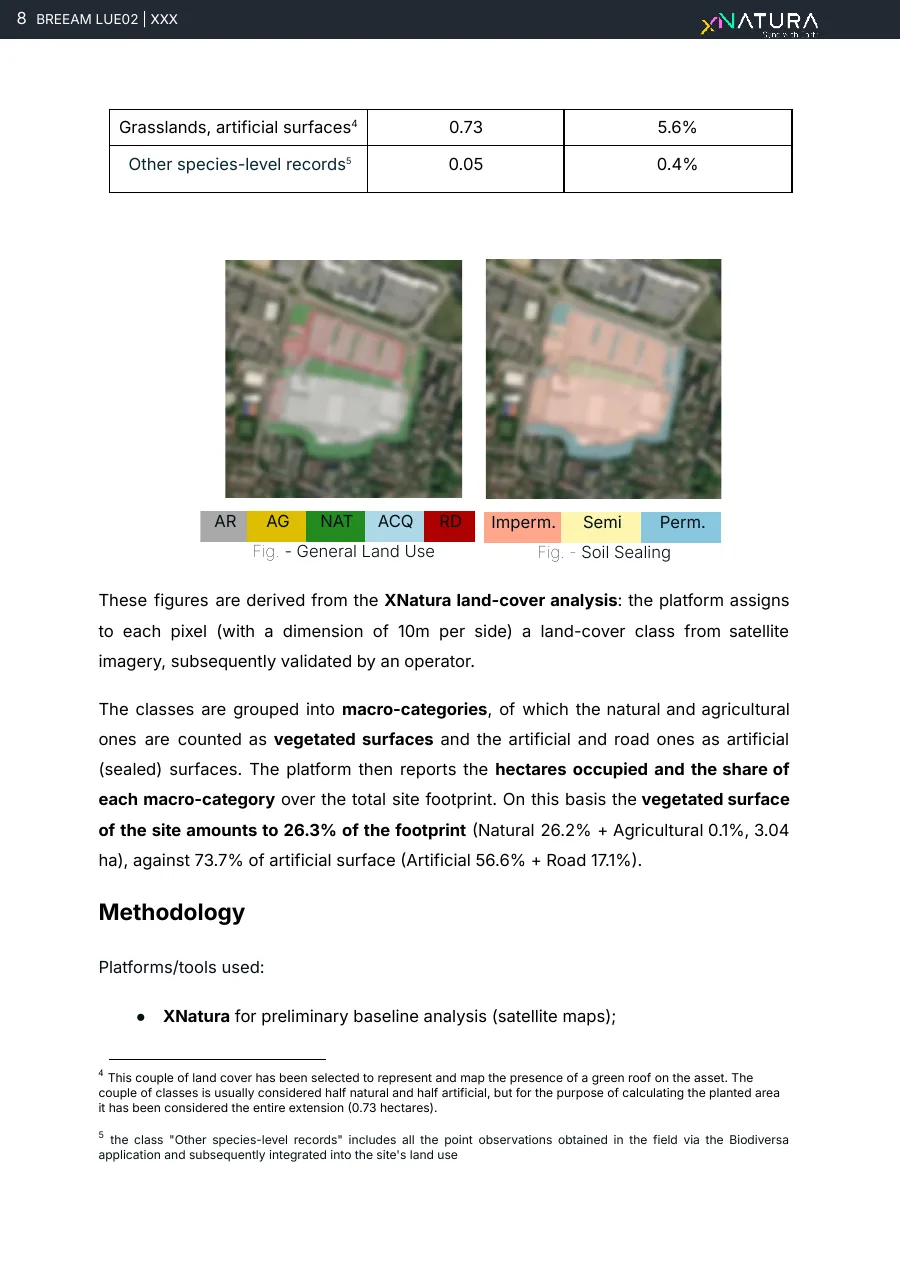
Sealed surfaces
- From the platform
What the credit asks for
How much soil is sealed and how much surface stays vegetated.
How we produce it
The two maps side by side, general land use and soil sealing, show where the 73.7 per cent sealed surface is and where the green is: the basis for measuring the planted areas.
Who does it Platform, validated by an operator
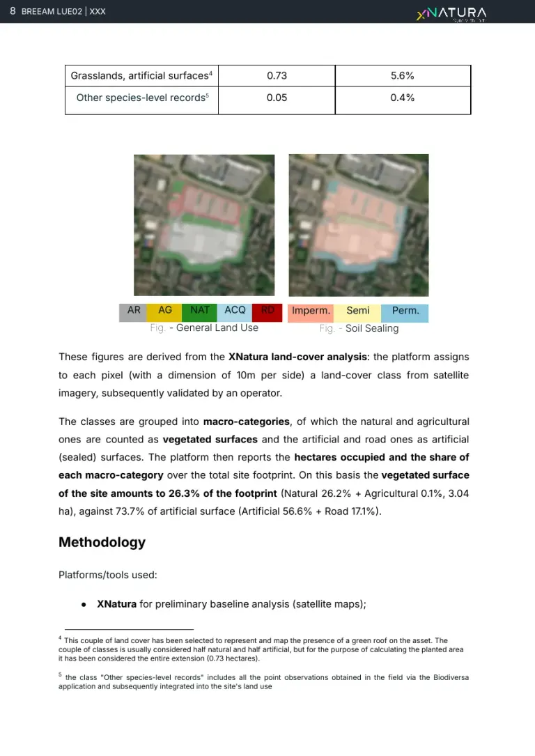
Real page · LUE 02, delivered report, anonymised · p. 8/22Download the report The field survey06 / 20
Method and sources
- From the team, in the field and on the data
What the credit asks for
How the survey was done, on which areas, and with which sources for species origin and invasiveness.
How we produce it
Site visit on 27 May 2026 across planters, green areas and the vegetated belt, with Biodiversa for the census; species origin from EASIN and invasiveness from EU Regulation 1143/2014 and the regional list.
Who does it Team agronomist
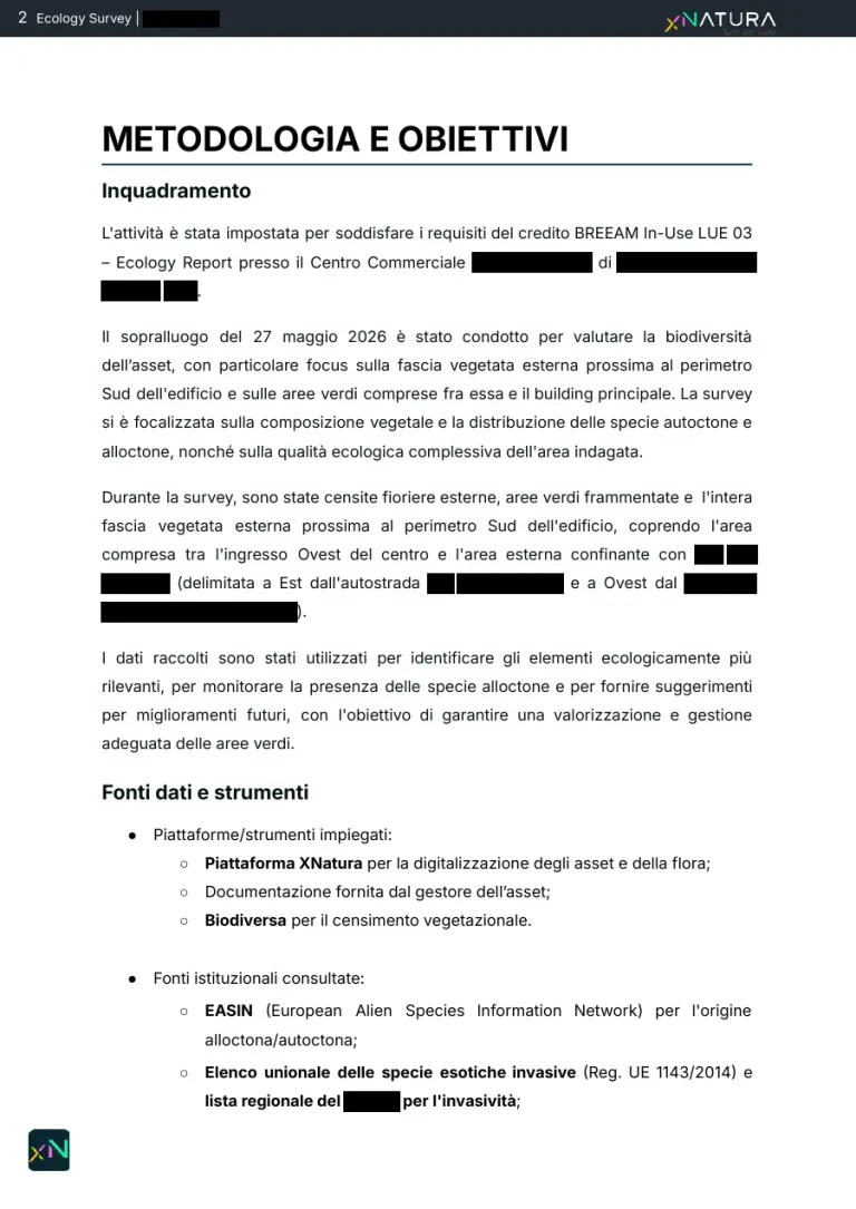
Real page · LUE 03, delivered report, anonymised · p. 3/15Download the report The field survey07 / 20
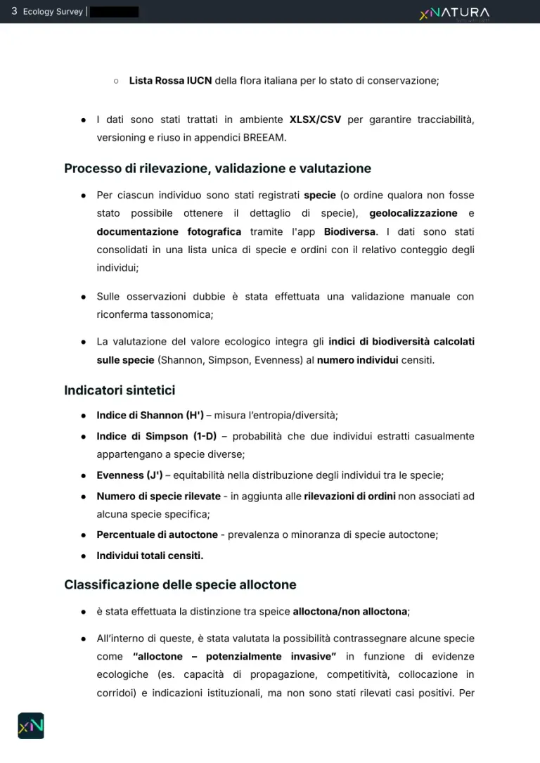
Survey, validation, assessment
- From the team, in the field and on the data
What the credit asks for
What is recorded for each plant and how the data is checked before it is assessed.
How we produce it
For each individual: species, position and photo with the Biodiversa app, consolidated into a single list with counts; doubtful observations go through a manual taxonomic re-check, and the data stays in traceable tables reused in the BREEAM annexes.
Who does it Team agronomist
Real page · LUE 03, delivered report, anonymised · p. 4/15Download the report The field survey08 / 20
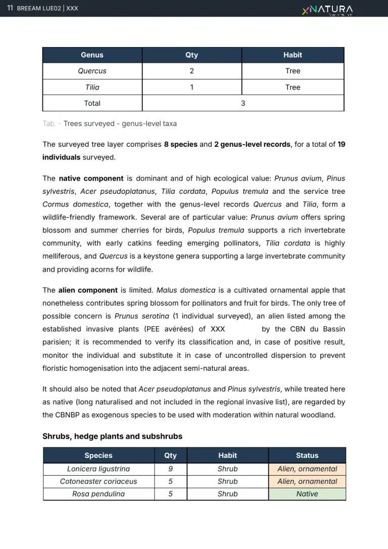
The trees surveyed
- From the team, in the field and on the data
What the credit asks for
Which trees are there, how many, native or alien.
How we produce it
8 species and 2 genera, 19 individuals: the native component dominates; the only tree of concern is one Prunus serotina, an established invasive on the regional list.
Who does it Team agronomist
Real page · LUE 02, delivered report, anonymised · p. 11/22Download the report The field survey09 / 20
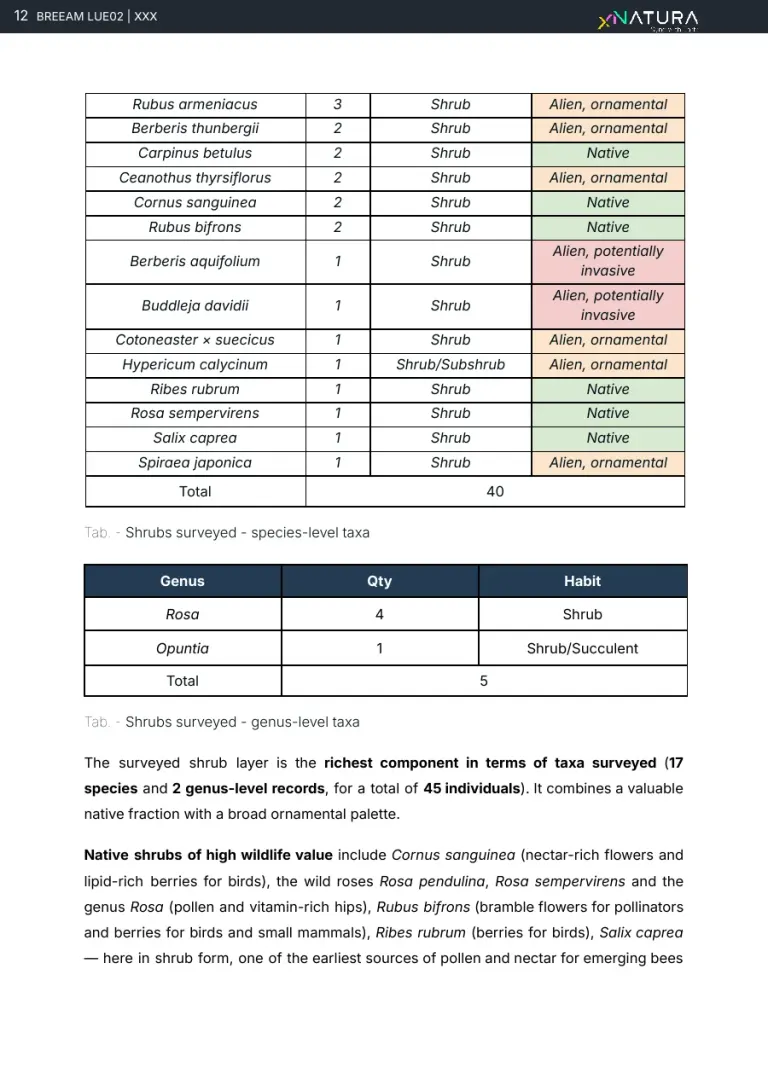
The shrubs, species by species
- From the team, in the field and on the data
What the credit asks for
The shrub component, with the status of each species.
How we produce it
The richest layer: 17 species and 2 genera, 45 individuals, each with habit and status (native, ornamental, potentially invasive) highlighted in colour.
Who does it Team agronomist
Real page · LUE 02, delivered report, anonymised · p. 12/22Download the report The field survey10 / 20
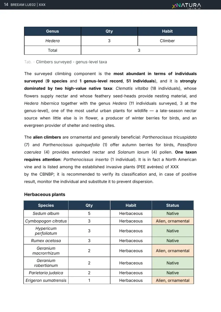
Climbers and green walls
- From the team, in the field and on the data
What the credit asks for
The green walls and the other alternative planted areas the credit recognises.
How we produce it
The component with most individuals: 9 species and 1 genus, 51 individuals, dominated by two high-value natives such as Clematis vitalba; a single taxon to watch.
Who does it Team agronomist
Real page · LUE 02, delivered report, anonymised · p. 14/22Download the report The field survey11 / 20
Native and alien at a glance
- From the team, in the field and on the data
What the credit asks for
The overall picture: how many species and individuals are native, ornamental or invasive.
How we produce it
Across 139 individuals and 50 taxa, natives are 23 species out of 45 (51.1 per cent) and 70 individuals (50.4); 2 potentially invasive species and 2 established invasives.
Who does it Team agronomist
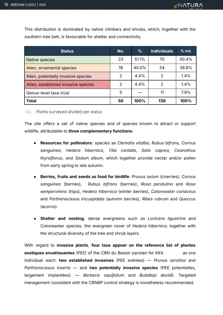
Real page · LUE 02, delivered report, anonymised · p. 16/22Download the report The indicators12 / 20
The census results
- From the team, in the field and on the data
What the credit asks for
What was found and which indicators read the ecological value of the area.
How we produce it
483 individuals sampled, 54 validated species and 8 orders; ecological value is read through diversity (Shannon, Simpson), evenness, richness, structure, functional position and alien species.
Who does it Team agronomist
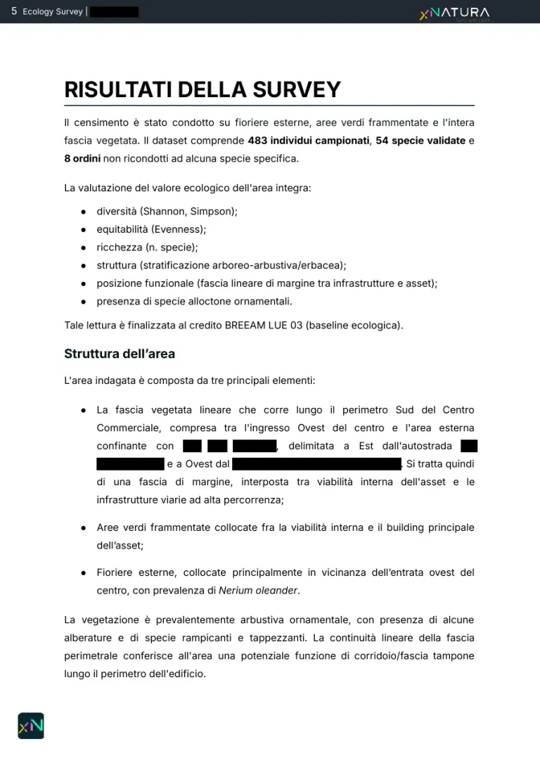
Real page · LUE 03, delivered report, anonymised · p. 6/15Download the report The indicators13 / 20
The dominant species
- From the team, in the field and on the data
What the credit asks for
Which species make up the plant community and how much they weigh.
How we produce it
Ornamental shrubs dominate (Nerium oleander leads with 87 individuals), but the most abundant also include notable natives such as Rosa pendulina (48) and Cotinus coggygria (25).
Who does it Team agronomist
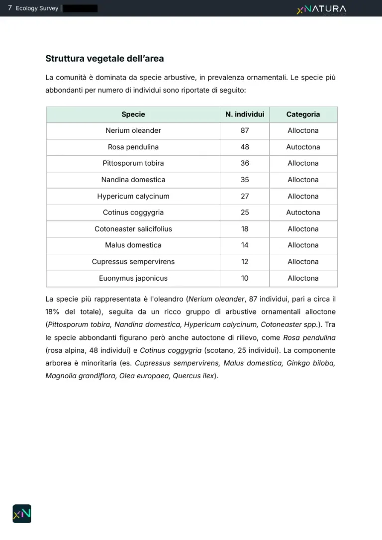
Real page · LUE 03, delivered report, anonymised · p. 8/15Download the report The indicators14 / 20
Distribution by origin
- From the team, in the field and on the data
What the credit asks for
How much of the community is native and how much alien.
How we produce it
Alien: 39 species and 74.2 per cent of individuals; native: 15 species and 25.8; taxa resolved only to genus stay out of the calculation, listed separately.
Who does it Team agronomist
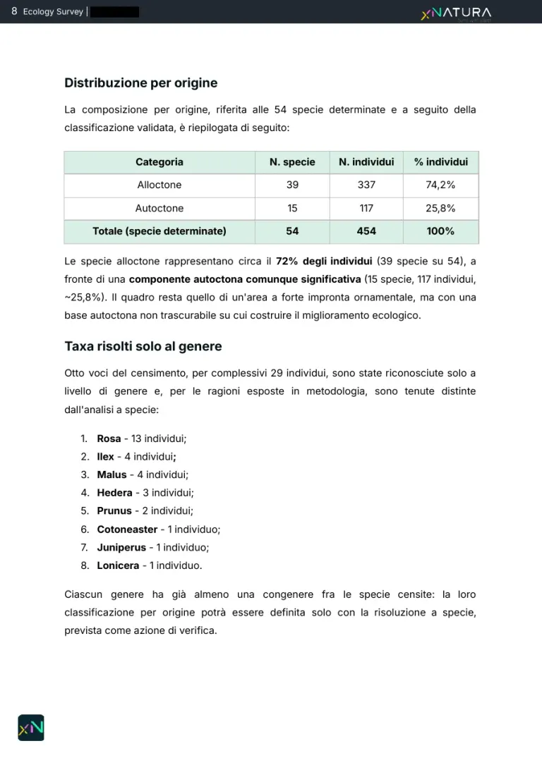
Real page · LUE 03, delivered report, anonymised · p. 9/15Download the report The recommendations15 / 20
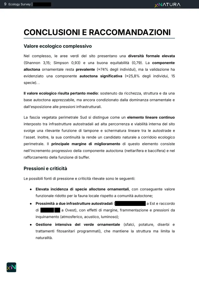
Overall ecological value
- From the team, in the field and on the data
What the credit asks for
A judgement on the area's ecological value, with its strengths and pressures.
How we produce it
High formal diversity (Shannon 3.15, Simpson 0.93) and good evenness (0.79), with a prevailing ornamental component: the judgement holds both facts together.
Who does it Team agronomist
Real page · LUE 03, delivered report, anonymised · p. 10/15Download the report The recommendations16 / 20
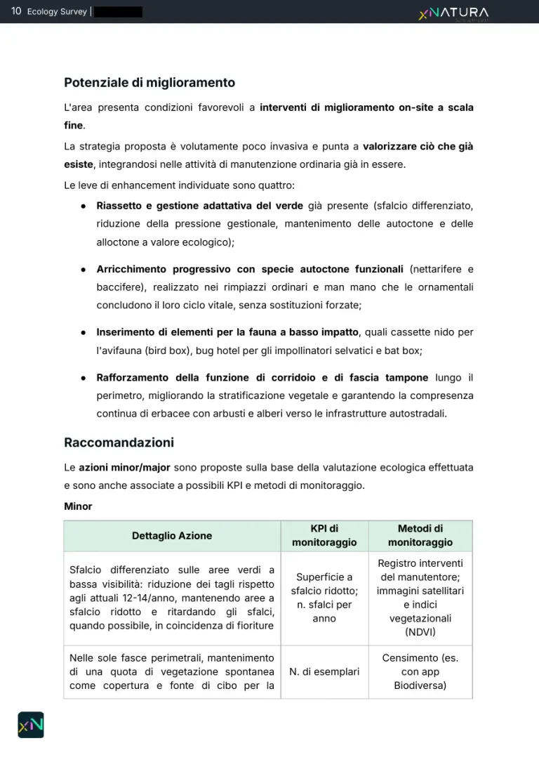
Room for improvement
- From the team, in the field and on the data
What the credit asks for
Where and how to improve, without overturning how the green areas are managed.
How we produce it
Four low-impact levers within routine maintenance: adaptive management of the existing green, gradual enrichment with nectar and berry-bearing natives, features for wildlife, a stronger corridor and buffer strip along the perimeter.
Who does it Team agronomist
Real page · LUE 03, delivered report, anonymised · p. 11/15Download the report The recommendations17 / 20
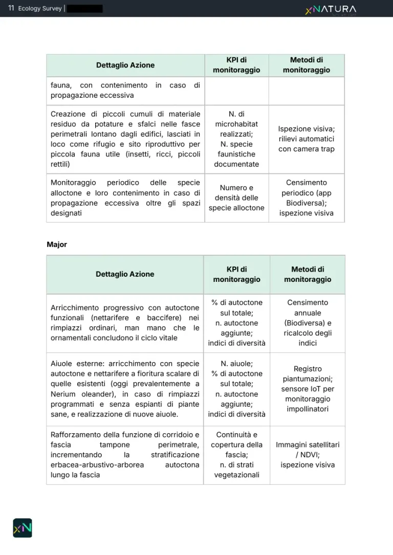
Actions with KPIs and a monitoring method
- From the team, in the field and on the data
What the credit asks for
For each action, how the result is measured and with which tool.
How we produce it
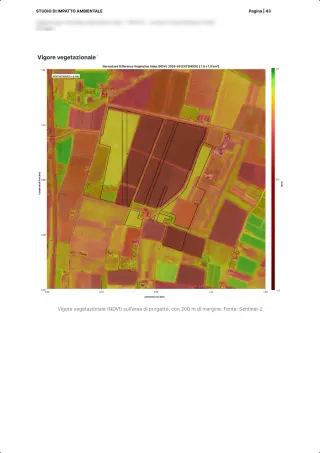
Each action has its KPI and its method: an annual census with Biodiversa, camera traps, pollinator sensors, satellite imagery and NDVI.
Who does it Team agronomist
Real page · LUE 03, delivered report, anonymised · p. 12/15Download the report The recommendations18 / 20
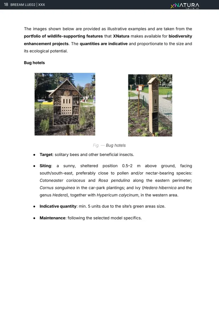
Features for wildlife: bug hotels
- From the team, in the field and on the data
What the credit asks for
The wildlife features that are missing to move up an answer in the credit.
How we produce it
Examples from the catalogue of biodiversity features, with target species, siting and an indicative quantity in proportion to the site.
Who does it Team agronomist
Real page · LUE 02, delivered report, anonymised · p. 18/22Download the report The recommendations19 / 20
Nest boxes and bat boxes
- From the team, in the field and on the data
What the credit asks for
Where and how to install shelters for birds and bats.
How we produce it
For each feature: target species, height and orientation, spacing, indicative quantity and maintenance.
Who does it Team agronomist
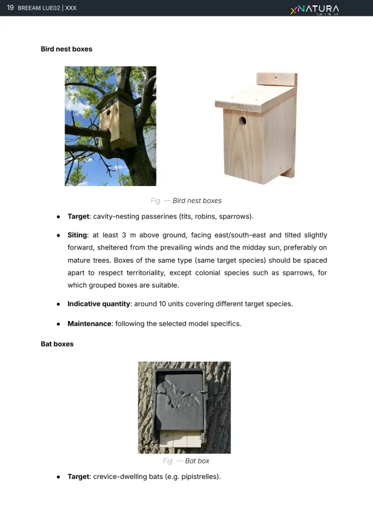
Real page · LUE 02, delivered report, anonymised · p. 19/22Download the report The recommendations20 / 20
The proposed answer
- From the team, in the field and on the data
What the credit asks for
Which answer of the credit the evidence supports, and what the next one needs.
How we produce it
Answer C, 1 credit: at least two recognised ecological features are present. Recommendations 1 and 2 complete all four and support answer D, 2 credits.
Who does it Team ecologist, the decision stays with the assessor
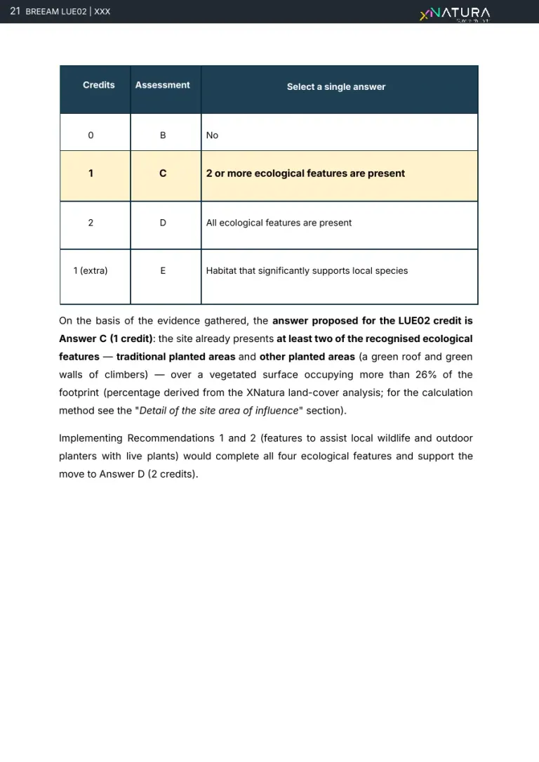
Real page · LUE 02, delivered report, anonymised · p. 21/22Download the report
How the maps are made
From satellite to the land use of the site.
The report's site framing is computed on the perimeter of the asset and on its area of influence: land use, sealed surfaces and vegetated surface, with legend and source.
Satellites and datasets
Open imagery and data, updated over time.
One class per pixel
The platform gives each 10 metre pixel a land-cover class, then validated by an operator.
5 macro-categories
Artificial, agricultural, natural, water and road: hectares and share of the site and of its surroundings.
Vegetated surface
Natural and agricultural count as vegetated, artificial and roads as sealed: the basis of the credit's planted areas.
Same area, two layers
Switch the layer, the perimeter stays put.
The two figures come from the LUE 02 report above, blurred as in the anonymised report. Same area, same scale: land use by category and the degree of soil sealing can be compared without redrawing anything.

Land Use 
Impervious Land Ratio 
Natural Habitat Coverage 
Built-Up Surface 
Water Coverage 
MSA Plants 
PA Relative Pollinator Abundance 
PN Nectar Potential 
NS Suitability for nesting 
Observations
Indicator cards of the XNatura platform, from the site's Satellite maps page. The platform's satellite maps
In the field with Biodiversa
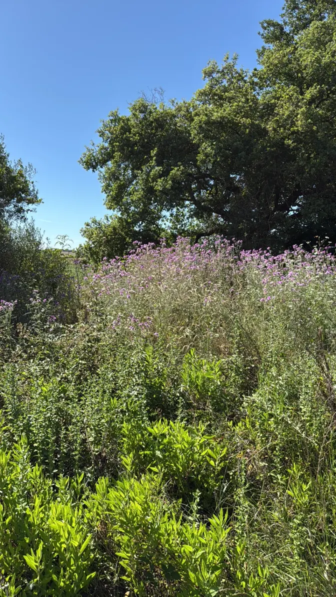
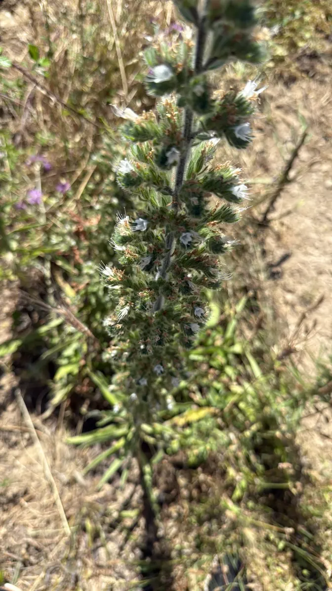
The satellite says where the green is. The survey says what is in it.
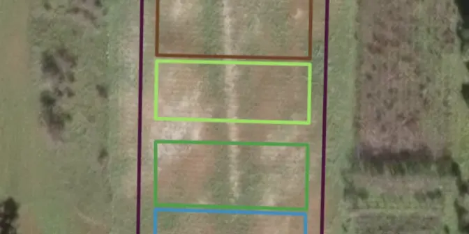
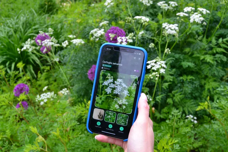
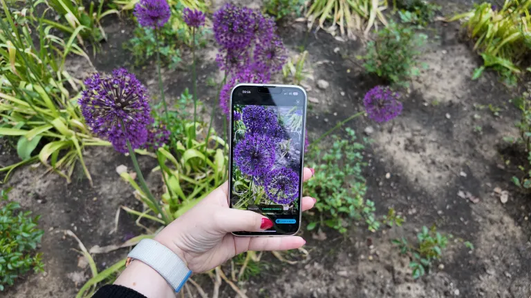
In both reports the census is done with the Biodiversa app: every plant with its species, position and photo, consolidated into a single list and validated before the assessment. The same tables end up in the report's annexes.
- FieldSurvey with the app
- CheckValidated by the expert
- DataCensus observations
- ReportThe record shows up in the report
The Nature Experts
We support the qualified ecologist. We do not replace them.
A BREEAM report is not an export of maps: someone has to read the site, propose an answer and back it with evidence. Our team does, alongside the project's qualified ecologist; the BREEAM assessor chooses the credit's answer.
- 01PrepareLand use, census and tables from the platform and from Biodiversa
- 02InterpretEcologist and agronomist read the data and propose the credit's answer
- 03DocumentEvery answer with its evidence, for the assessor and the qualified ecologist
- 40+in-house nature, climate and ESG specialists
- 7disciplines under one roof
- 10years of track record
Who works on a BREEAM report
Ecologist
Sets up the survey, reads habitats and plant communities, proposes the credit's answer with the evidence behind it.
Agronomist
Surveys trees, shrubs, climbers and herbaceous plants species by species, with origin and invasiveness checked against official sources.
Zoologist
Points out the missing features for wildlife: bug hotels, nest boxes and bat boxes, with target species, siting and quantity.
The project's qualified ecologist
We work for them with traceable data, maps and tables. The judgements that are theirs stay theirs: we support them, we do not replace them.
BREEAM assessor
Chooses the credit's answer on the report's evidence, which the report lays out criterion by criterion.
The team's disciplines
 Ecology & biodiversityBiologists, zoologists, environmental scientists: baselines, surveys, camera traps, bioacoustics, telemetry.
 Assessment, reporting & complianceESRS E4, BNG, SBTN, GRI, EIA/SEA, VIncA, BREEAM/LEED. Board- and authority-ready.
 Agronomy & land useRegenerative agriculture, supply chains, land and vegetation management.
 Data & remote sensingGIS, satellite analysis, IoT data, predictive models, digital twinning.
 Climate & riskIPCC scenarios, physical risk, wildfire and water modelling per asset.
 Strategy & deliveryNature strategy, action plans, green finance, stakeholder engagement, client training.

Example reports
See what you receive: real reports, anonymised
Deliverables our experts signed for real clients, with names, places and coordinates removed. Pick one, leave your details and download the PDF straight away.
Your report is ready.
Open it now; a strategist may follow up if it fits a project of yours.
Download the PDF ↓Our systems are temporarily unreachable and the request did not go through. Try again, or write to info@3bee.com.
The voice that guides you through the report
Ask, and the page takes you there.
A voice assistant always within reach, bottom right. Ask it about a section of the report, a credit or who does what: it answers and brings the page to the right point.
- It answers about this page: the LUE 02 and LUE 03 credits, how we produce each section, what stays with the assessor.
- It walks you through the document: it scrolls to the section and highlights it while you keep talking.
- If you want a first analysis of your site on the platform, it prepares it, and you open it on XNatura after signing in.
You can ask, for example
- Take me to the field survey
- What does the LUE 02 credit ask for?
- How do you tell an invasive species?
- Who chooses the credit's answer?
- I'd like a first analysis of my site on the platform
Contact
A Land Use & Ecology credit to prepare?
Tell us about the asset, the scheme and the assessment deadline. A named strategist replies within 24 working hours.
The example reportsReal reports, delivered and anonymised: the LUE 02 credit for planted areas and the LUE 03 ecology report.Choose and download30 minutes with the XNatura team
Video call on Google Meet
Would you rather talk it through?
Either way you are speaking with an AI assistant, and the conversation is transcribed. How we handle your data
Tell us about the asset
Request sent.
One of our strategists replies within 24 working hours. If you need us sooner, write to info@3bee.com.
Our systems are temporarily unreachable and the request did not go through. Try again, or write to info@3bee.com.
We could not verify that the request comes from a person, so it was not sent. Reload the page and try again. You can also write to info@3bee.com or call +39 030 204 1767.
FAQ
Frequently asked questions on the BREEAM ecology report
Which BREEAM credits do the reports on this page show?
Two credits of the Land Use & Ecology category of BREEAM In-Use V6: LUE 02, the ecological features of planted areas, and LUE 03, the ecology report. The pages come from two delivered, anonymised reports, which you can download among the example reports.
Do you replace the qualified ecologist?
No, we support them. The platform and the team prepare the site framing, the census and the tables, traceable down to the single observation; the judgements that belong to the qualified ecologist stay theirs, and the BREEAM assessor chooses the credit's answer on the report's evidence.
What comes from satellite and what from the field?
From satellite: the site area, land use and sealed surfaces, with one class for each 10 metre pixel validated by an operator. From the field: the census with the Biodiversa app, plant by plant, with species, position and photo, validated before the assessment.
How do you tell whether a species is native or invasive?
Origin comes from EASIN, the European Alien Species Information Network; invasiveness from the Union list of EU Regulation 1143/2014 and from the regional list. Doubtful observations go through a manual taxonomic re-check, and taxa resolved only to genus stay out of the calculations.
What do the recommendations contain?
Minor and major actions, within the routine maintenance of the green areas, each with its KPI and monitoring method: an annual census with Biodiversa, camera traps, pollinator sensors, satellite imagery and NDVI. For wildlife, bug hotels, nest boxes and bat boxes with target species, siting and an indicative quantity.
Which language do you deliver the report in?
Italian or English: of the two example reports, LUE 03 is in Italian and LUE 02 in English. The pages shown here stay in the language they were delivered in.
XNatura · AI
Voice assistant
Ask me about a section of the report, a credit or who does what: I'll take you where you need to be.
You can ask, for example
- Take me to the field survey
- What does the LUE 02 credit ask for?
- How do you tell an invasive species?
- Who chooses the credit's answer?
- I'd like a first analysis of my site on the platform
You’ll speak with XNatura’s AI assistant. Your microphone only starts with your permission. You can review and confirm your details before sending a request. If the assistant prepares a demo for you, the site’s name and location go to the XNatura platform, which keeps them for one hour so you can open it. How we use your data
Getting your conversation ready…
The conversation
Start with a question or tell us what you need.
Your project updates as you speak
Review and send your request